Accumulating Snow To Disrupt Morning Commute
PHILADELPHIA (CBS)--Winter made a brutal return to the area early Friday morning, when one of two potential snowstorms in the next week made its arrival in our region.
It seems almost unbelievable that we could be talking about accumulating snow on the heels of not only a near-70 degree day today but also the stretch of insane warmth we've had lately.
It was only a couple of weeks ago that temperatures were near 80 in Philadelphia! But March has some tricks up it's sleeve and Friday morning we started to see these tricks play out.
Philadelphia International Airport says the snow has not significantly impacted flights. There have been some delays but nothing "out of the ordinary." The airport encourages people to check their website for updates.
TIMING:
The snow overspread the area in the wee hours of Friday morning, pushing from north to south. In parts of our area, especially the Lehigh Valley and the Poconos, the snow may fall at a pretty intense rate through the morning hours, allowing it to overcome the warm boundary layer temperatures and accumulate, even sticking to some roads (especially side streets and untreated surfaces). This is the area that will see the greatest amount of accumulation, in the 3-6" range – likely closer to 3" for the cities in the Lehigh Valley, highest amounts in that range in the highest elevations.
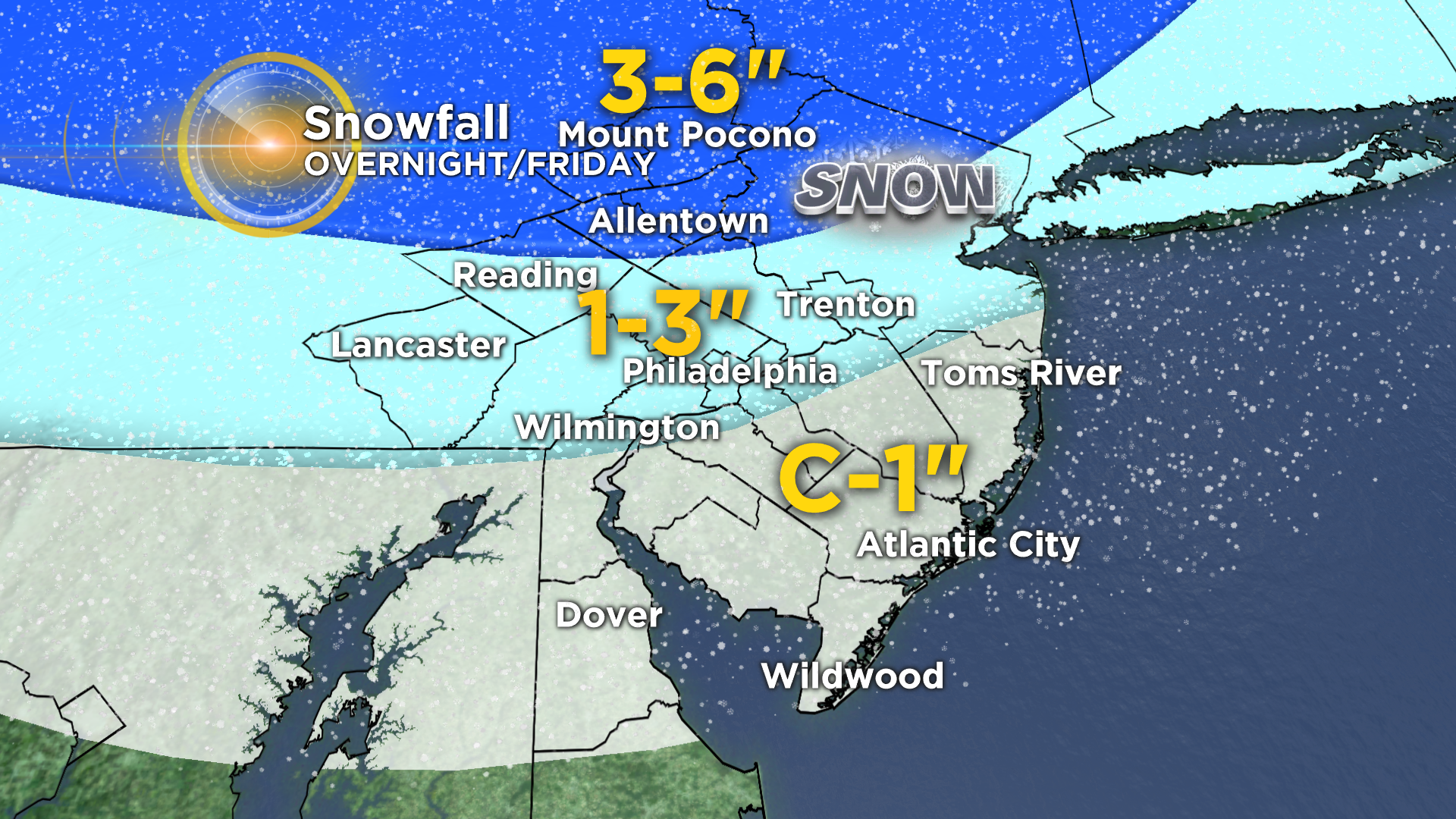
In Philadelphia, the snow will FALL heavily for a few hours, but it may start as "white rain", so to speak, as it will melt on contact. I do think we're likely to pick up a slushy inch, maybe two, on grassy surfaces. Even if this doesn't stick to the roads and main roads stay wet, which looks probable, we'll see snow falling at a good clip through the morning rush, leading to reduced visibility and major slowdowns. The main event will taper after 10-11 a.m., but through the afternoon the wind will pick up and we'll be tracking scattered snow showers and squalls which could again drop the visibility dramatically.
TRACKING SNOW: Latest Forecast | Radar | Traffic Map | School Closings/Delays

LOOKING TO THE WEEKEND
Over the weekend, we tap into some really brutal cold from the polar regions. If you thought last weekend was cold, wait until you see what this weekend has on offer. Wind chills will be near zero at times Saturday and Sunday mornings, with daytime wind chills in the teens as temperatures hover around the freezing mark both days.
ANOTHER STORM?
And then we shift focus to another potential snowstorm – this one a coastal storm taking shape for Tuesday of next week. This storm has a lot of potential and a lot going right for it, atmospherically.
There is already a good deal of model consensus, which is something we haven't seen much of lately. But there are still more questions than answers. First, the track of the main low. Does it get pushed out to sea and miss east before heading up to New England? Does it track inland along the coast, leading to p-type issues (i.e. rain, sleet, etc.)? Or does it tuck in and strengthen just off the coast, bringing major nor-easter snowfall to our area?
There are many factors at play in the atmosphere that make things murky at the moment, and we really have to wait until after the first storm passes tomorrow and we get into the weekend before we see how all the players on the field are lining up.
Suffice it to say, we have to at least be on alert for a potential major east coast late-season storm next week, and the specifics on timing and impact will be forthcoming in the next several days.