PHILADELPHIA WEATHER GUIDE: How Much Snow Will Major Nor'easter Dump On Your Area?
PHILADELPHIA (CBS) -- A major nor'easter will brew on Friday and make its way up the northeast coast Saturday.
What is a bomb cyclone?
This storm is going to be a big one, no matter how you slice it. It's expected to "bomb out," which is a term we use to describe the process of bombogenesis, or rapid intensification.
The generally accepted definition of bombogenesis is a storm that drops at least 24 millibars of pressure in 24 hours. Remember, lowering pressure equals strengthening storm.
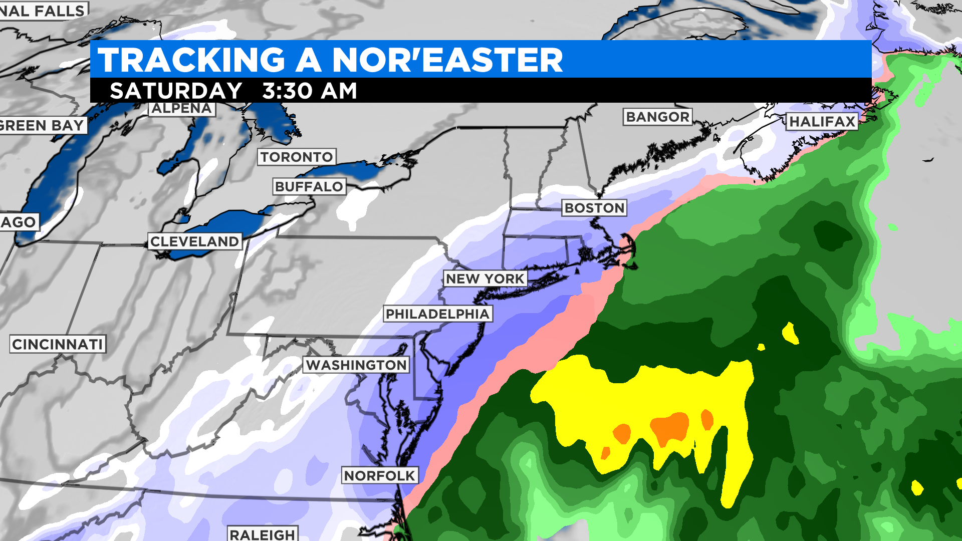
Current modeling of this system shows the pressure dropping from around 996mb at 1 o'clock Saturday morning to 964mb by 1 o'clock Sunday morning -- a drop of 28mb, which is the very definition of bombogenesis. The strengthening will be occurring as the storm makes its way past our coastline, but the storm will be at its peak off the coast of New England, which looks to be the hardest hit spot with this storm.
Current thinking
If you've been tracking this storm with us over the past few days, you'll know that this storm has had an unusually high amount of model disagreement. With a storm as potent as this one, the track is like a tightrope act. Half a mile to the west and Philadelphia gets hardly any snow, a shift back to the east means a major snowstorm. It's a tricky forecast to say the least.
Currently, we do have better agreement amongst our model suite. All signs point to a storm that does not hug the coast -- which would be the blockbuster top-20 snowstorm in our area -- but also doesn't miss completely wide right. This track would mean a major snowstorm at the coast with lessening impacts the farther inland you go.
Important
There is still uncertainty about this storm, specifically with the western edge of the snow shield. The cutoff will be sharp and thus amounts may underperform from the city on west, especially with any slight jog to the east.
There will also be dry air pushing in behind the storm which could eat away at some of the snow.
However, with some lifting into the higher terrain to our north and west, we are still expecting to see at least some snow there.
Timeline
During the day Friday, expect to see some areas of light snow or snow showers with the arctic cold front.
Late Friday night, by 9 or 10 p.m., snow will begin to move onshore along the coast.
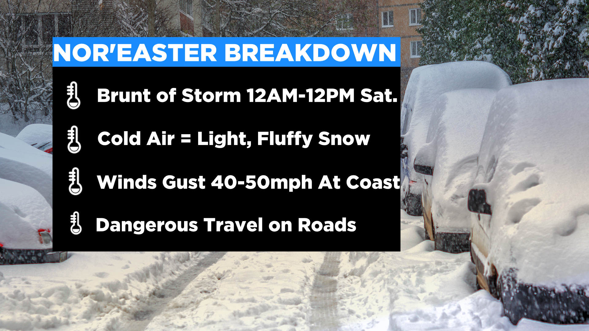
The brunt of the storm is midnight to noon on Saturday, with the storm then ending from west to east Saturday afternoon.
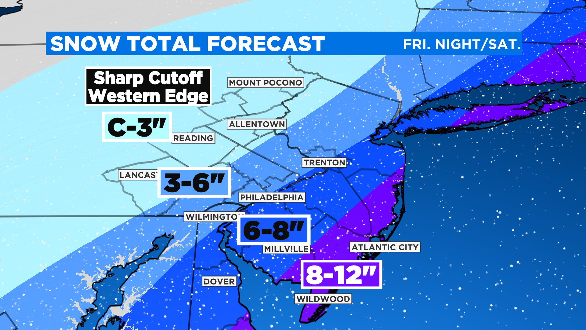
Snow
The question everyone has when a storm approaches: how much snow will I get? While this is still uncertain in spots, we've narrowed down the forecast to present the most likely totals at this time.
The heaviest snow will be along the coast where 8-12 inches could fall, potentially some localized higher amounts.
Interior New Jersey is looking at 6-8 inches, while Philadelphia and the I-95 corridor fall right along that 6 inch line. I'd set the over/under at 6 inches at the airport right now but it could go either way. That's the battleground area.
3-6 inches is likely from the city into Lower Bucks and Montgomery Counties and New Castle County, Delaware.
The Lehigh Valley and the Poconos will see the least amount of snow, with a general coating to 3 inches, and the understanding that a sharp enough cutoff could mean little to no snow at all.
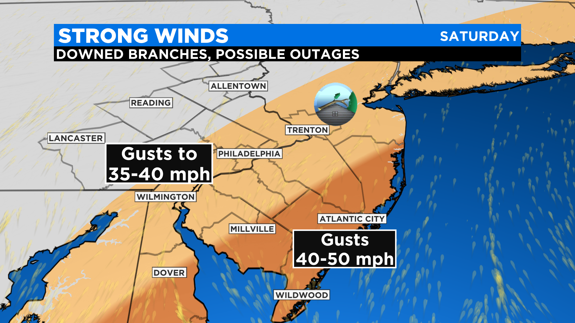
Winds
Winds along the coast may gust as high as 40-50 mph. Coupled with the heavy snow, this will lead to blowing and drifting and very low visibility. Winds may also be strong enough to bring down tree branches, leading to power outages.
Inland New Jersey and near the city, expect wind gusts as high as 40 mph, with 25-35 mph gusts to the northwest of the city.
Coastal flooding
Minor coastal flooding is forecast at high tide times on Saturday, though it looks like we'll be spared the worst of it since the period of easterly winds is relatively limited.
A few notes
Very cold air will be present for this storm, thanks to both the arctic front and the overnight timing, so we expect this to be fluffy, high-ratio snow, meaning more like a 12:1 ratio of snow to water content.
Winds behind the storm Saturday will continue to be quite strong with gusts over 35 mph. This will lead to sub-zero wind chills Saturday night, which could be very dangerous for those without power. Make sure to have a plan in place for a power outage, especially if you live close to the coast.
In a tiny bit of better news, we'll start February next week with a winter warmup. Highs are expected to surge into the 50s by Wednesday!