Philadelphia Weather: Winter Storm Warning Issued Ahead Of System That Could Drop Up To 8 Inches Of Snow Across Region
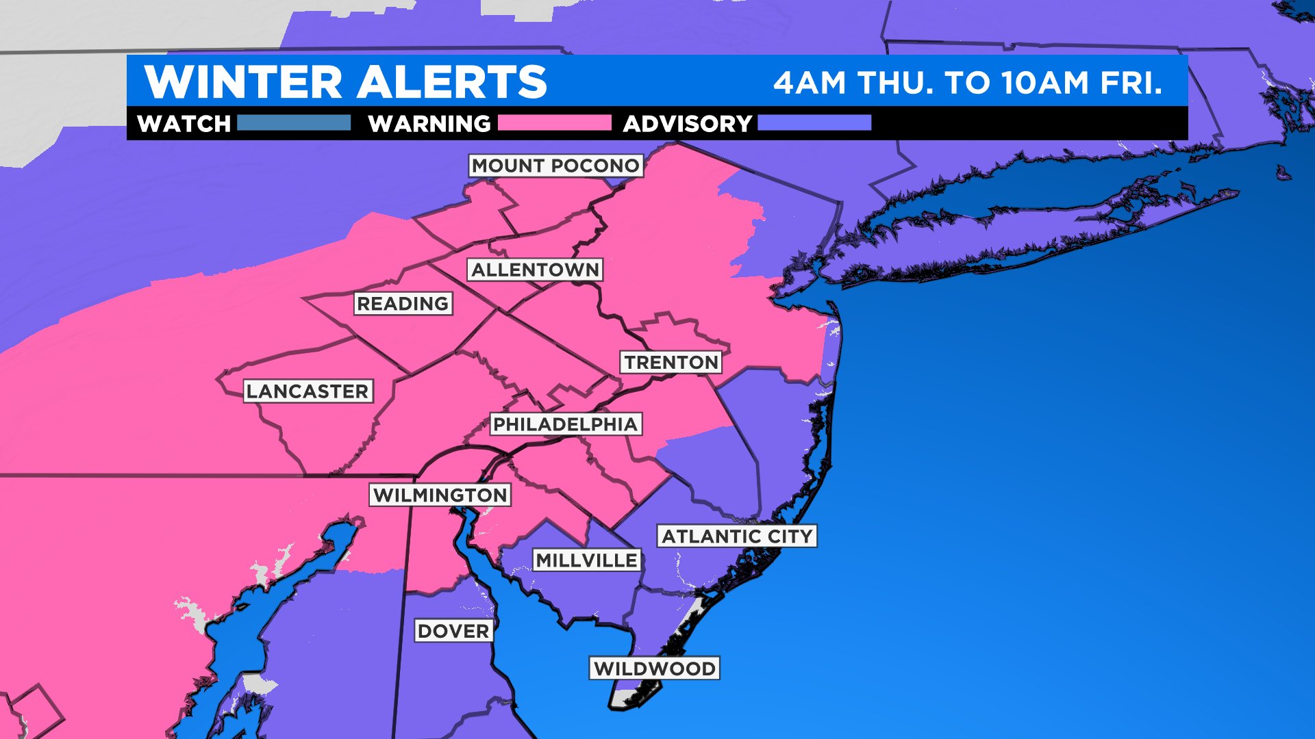
PHILADELPHIA (CBS) -- A powerful winter storm is set to affect the region starting as early as tonight in some areas, but really should pick up in intensity through Thursday morning, lasting into Friday. The National Weather Service issued a winter storm warning for the Delaware Valley that will go into effect from 4 a.m. Thursday until 10 a.m. on Friday.
Snow flurries, or even a few areas of light snow, are possible across the Lehigh Valley or Poconos tonight as the system starts to move in. However, the bulk of the precipitation will not start until daybreak or slightly before Thursday, for a majority of the region.
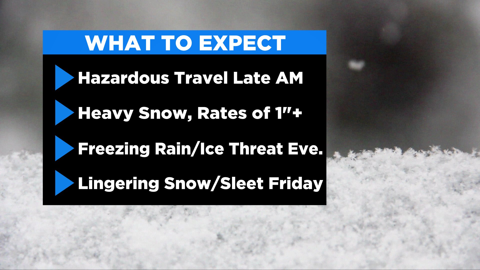
Once the snow begins, it will be heaviest from 7 a.m. or 8 a.m. through 1 p.m. on Thursday afternoon. During this time, we could have snowfall rates of up to 1 inch per hour in some spots.
Once we get beyond the midday hours, we will be watching to see how much warm air can intrude into the region. At this time, it looks as though we should see a change to more of a wintry mix as we move through the afternoon and into the evening hours.
This mix will include snow, sleet, and even some freezing rain at times. Precipitation rates during the afternoon will remain steady, with some heavier pockets. Travel is discouraged on Thursday morning and afternoon.
At this time, the heaviest snow looks to fall just north of Philly, from areas in Lower Bucks and Montgomery Counties, up through the Lehigh Valley and the Poconos.
Snow will still likely accumulate across portions of interior South Jersey, including the New Jersey suburbs of Philly, but there will be a better chance for mixing in these communities so snow totals will be lower.
As you get closer to the Jersey Shore, an eventual change to all rain is likely in the afternoon on Thursday, so while an initial burst of snow is possible early, with a pretty quick transition to sleet and then rain will be likely, washing away most, if not all, of the snow from the morning.
The wintry precipitation will become slightly more scattered in nature in the later afternoon and evening, a trend that will continue into the overnight hours as well, as some extra dry air moves over the region. During this time, snow or wintry mix could still accumulate on the roads, so travel will still be difficult.
The scattered and lighter snow or a wintry mix will persist into Friday morning before it fairly quickly exits the region. Expect slippery and icy conditions on Friday morning on the roadways. Most of Friday should be dry with cloudy skies, however, some limited sunshine could peek through the clouds as the day progresses.
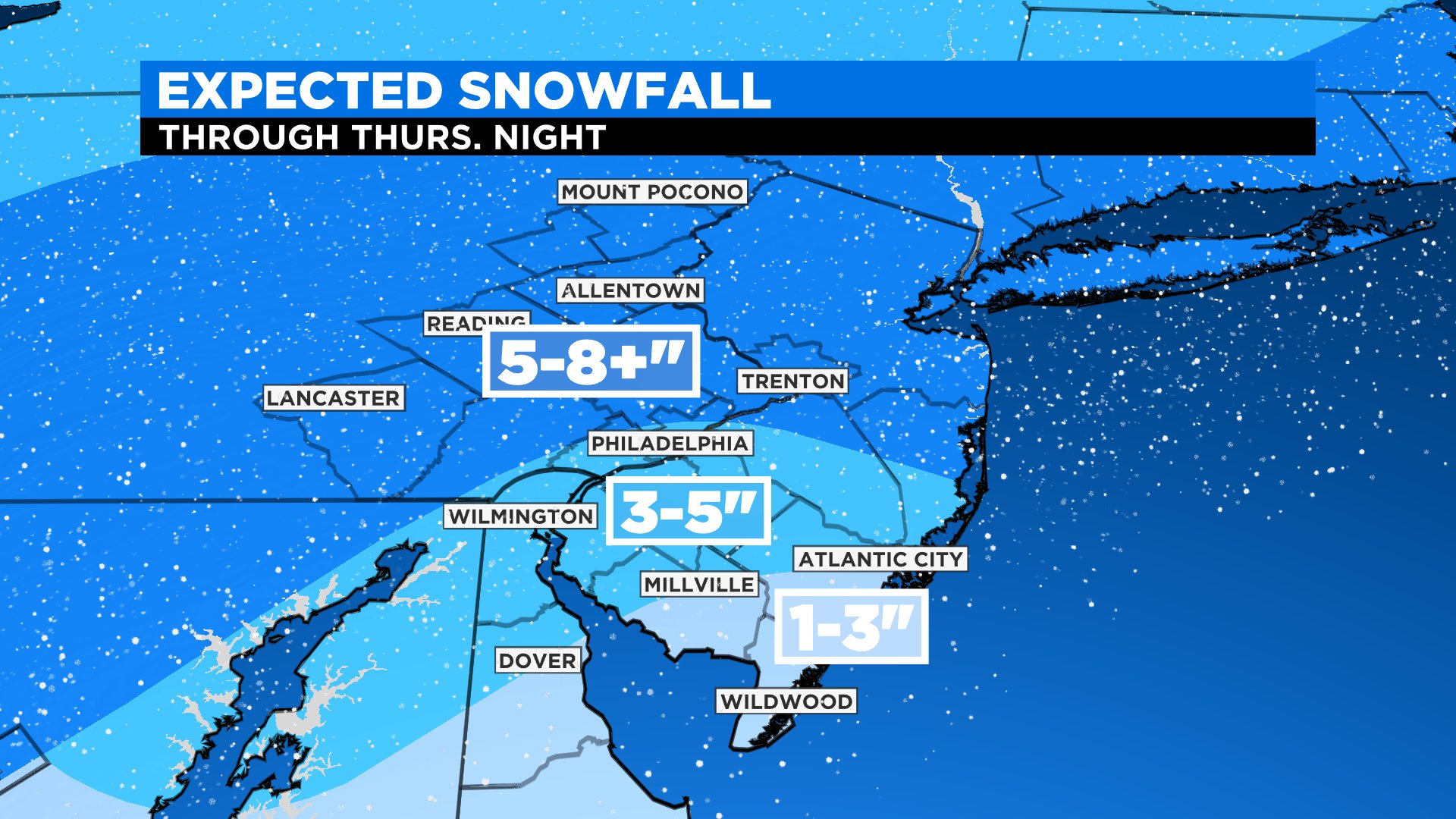
Snow totals will breakdown as follows:
Philly: On the line of 3-5/5-8 inches; Northeast Philly better chance to see the 5-8-inch range
Immediate Pennsylvania suburbs, Mercer County, New Jersey: 5-8 inches
Far N/W suburbs, Lehigh Valley, Berks County, Poconos: 5-8-plus inches
Immediate N.J. suburbs, interior South Jersey (Pine Barrens, etc.), north Delaware.: 3-5 inches
NJ Shore and Coastal Plain: 1-3inches, likely getting washed away by rain
Beyond this system, we will be watching another low that could develop and bring another round of wintry weather to the region early next week. Stay with the Eyewitness Weather Team for the latest on Thursday's winter storm.
CBS3's Matt Peterson and Lauren Casey contributed to this report.