Philadelphia Weather: Flooding Threat Ends Week As Parts Of Region Could See Over 2 Inches Of Rain
PHILADELPHIA (CBS) -- Clouds will continue to fill in today ahead of our next disturbance, which is scheduled to arrive on Thursday afternoon. The day will start off with showers, and rain will fill in from west to east as the afternoon approaches. Steady rain will develop in the second half of the day.
The rainy and cool pattern we have seen most of the month of April is looking like it will come to a climax just as the month ends this Friday.
A potent system that brought severe weather to portions of Texas and the deep south Tuesday night will move into the mid-Atlantic and through eastern Pennsylvania, New Jersey and Delaware over the next 48 hours.
As it does, it will likely dump multiple inches of rain, leading a flooding threat as the week ends. Strong winds and even a couple of thunderstorms are possible too.
It has felt like a pretty rainy month of April in Philly and even though our rain total for the month is pretty close to normal, we are going to be adding to it over the next couple of days, as this system works its way across the region.
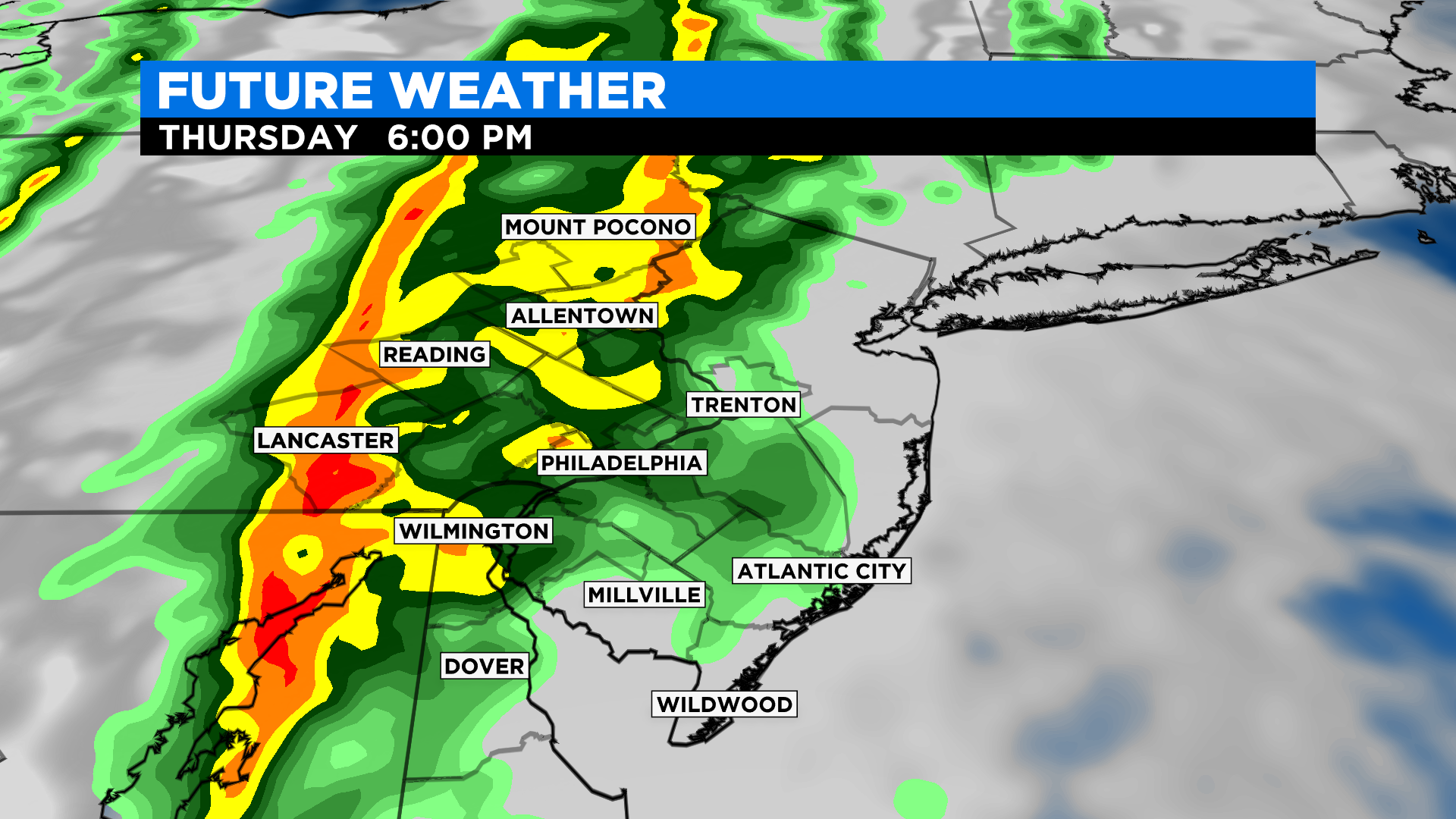
The first raindrops that we see with this system could fall as early as later Wednesday afternoon or evening, mainly in areas north and west of the city. The initial precipitation will be light and relatively spotty at best. As the night progresses, showers will again be held to mainly the north and west sections of the area, but we could start to see some rain move into areas closer to the Philly metro.
All overnight rain should remain pretty light. Expect an overall damp and dreary Thursday morning with winds that pick up as well. Most of the region, while it might feel damp, should stay dry most of Thursday morning.
Rain will increase in area and intensity in the afternoon as a cold front begins to approach from the west. The heaviest rain is most likely as the front crosses the Delaware Valley. We can expect this between 8 p.m. Thursday and 5 a.m. Friday.
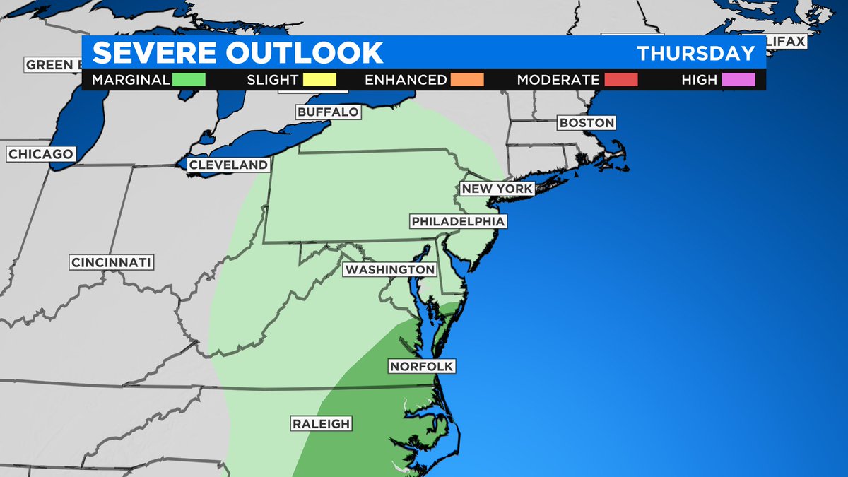
During the time of the frontal passage, we should also stay alert for a few thunderstorms as well. While this system has produced severe weather in the past, our threat of severe weather at this time is low.
However, we will continue to monitor the atmosphere to any potential changes that could lead to severe chances on Thursday. The low will then slow its progression, if not become stationary, on Friday as it sits just off to the northeast coast. This will allow for training of showers over the region on Friday.
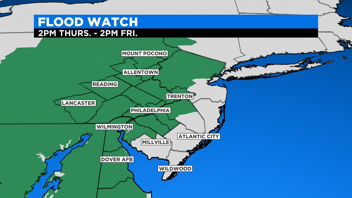
Training is when the same areas continue to see rain move over them time and time again. Due to the fact we likely get periods of heavy rain throughout Thursday and Thursday night, coupled with the training we could see into Friday, a flood watch has been issued for much of the region from 2 p.m. Thursday to 2 p.m. Friday.
The showers will likely taper off as we head into Friday night. A couple of extra lingering pockets of rain could be seen as late as Saturday morning, but by Saturday afternoon, we should see some clearing and sun could even break through before Saturday is all said and done.
Sunday should end the weekend with mostly sunny skies but a continued threat for a couple passing showers isn't totally ruled out.
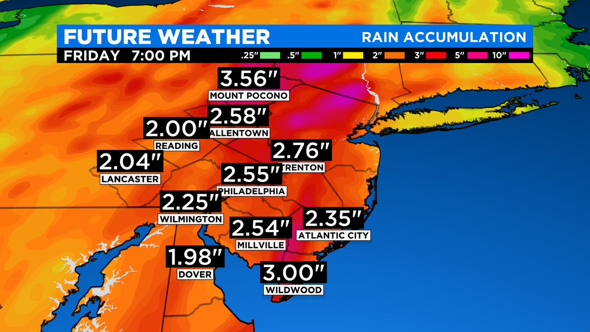
As mentioned, this system will have a lot of moisture to work with and that is why we are talking about the potential for flooding over the next couple of days. As this system works through, we can expect widespread rain amounts to push upwards of 2 inches.
In general, we should see 1.5 to 2.5 inches across a majority of the region, but if you find yourself caught in a thunderstorm or stuck in an area that sees the most training, there is the potential for up to 3-3.5-plus inches in spots.
The best chance to see the highest rain totals will likely be across the Lehigh Valley and Poconos at this time. This is again why we have a Flood Watch in place Thursday afternoon through Friday afternoon.
Make sure to remember to never drive through flooded roadways and to always stay weather aware and alert to changing weather conditions over the next couple of days.
CBS3's Llarisa Abreu and Matt Peterson contributed to this report