Philadelphia Weather: Snow To Develop Across Region, Turning To Wintry Mix By Evening Commute
PHILADELPHIA (CBS) -- After a relatively nice end to the weekend with seasonable temperatures and dry but breezy weather on Sunday, a dose of winter weather is going to affect the region on Monday. The set-up across Southeastern Pennsylvania and South Jersey on Monday will allow snow to develop in the morning before warm air noses in throughout the afternoon, eventually changing the snow to a bit of a wintry mix and eventually all rain.
A winter weather advisory has been issued for Philadelphia, all Pennsylvania suburbs and the Poconos from 1 p.m Monday until 7 a.m. on Tuesday.
The rain will then persist through Tuesday before we get some limited clearing later on Tuesday afternoon and evening.
Monday morning will start out with dry air in place over much of the region so that will likely hold the snow chances back a little bit -- at least at the onset of the system.
Expect snow to develop over the western suburbs likely around 7 a.m. or a little before.
Flurries or snow showers are likely to move into the Philly area around 8 a.m. before overtaking the whole region through the rest of the morning.
Overall, it looks as though the Monday morning commute will miss out on most of the snow, but we could still see some flurries or snow showers during the morning drive.
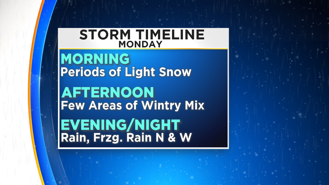
The best chance for snow in Philly and the immediate surrounding suburbs will be until about 2 p.m.
After that time warm air will start to nose in from the south and we could see it start to transition from all snow to a bit of a wintry mix, that could include sleet, snow, rain and freezing rain.
The transition time for Philadelphia and the I-95 corridor will be from 2 p.m. to 5 p.m.
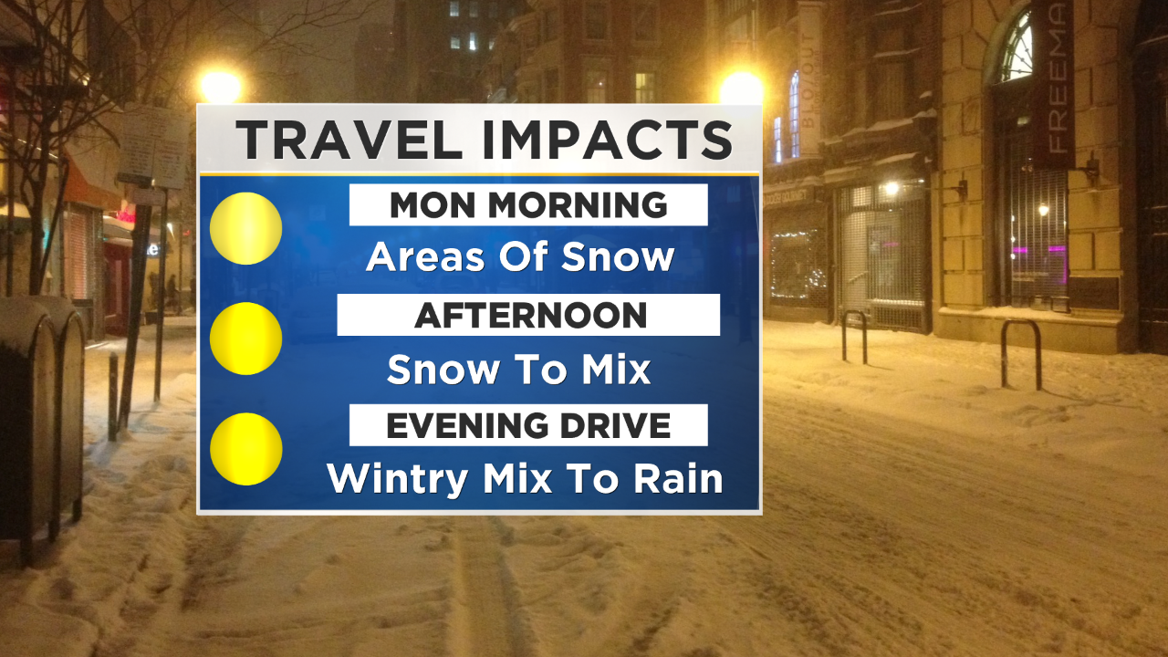
This means at least the start -- if not a majority -- of the evening commute will be slowed down by the threat of winter precipitation, leading to the potential for slick spots of the area roads, especially if they are untreated before the initial snow in the morning.
Warm air will continue to press into and through the region after the PM rush hour and the wintry mix will slowly change to all rain in the evening and through the overnight hours as well.
There could be a small lull in the action from the Monday night into the Tuesday morning timeframe, as the warm front moves farther to the north and we wait for the center of the low to slide just past us to the south.
Rain should ramp back up on Tuesday morning and we can expect rain showers throughout most of Tuesday with a gradual clearing of the rain and the clouds in the second half of the day and into the evening.
All precipitation on Tuesday should fall as rain since temperatures will be well above freezing across the whole region.
Snow amounts on Monday will be held to a relatively low amount due to the dry air in place at the start of the event -- and the warm air pushing in during the afternoon allowing for that transition to mix and rain.
We can expect one to two inches of snow in Philly and the immediate suburbs, with much of the area, closer to one-inch.
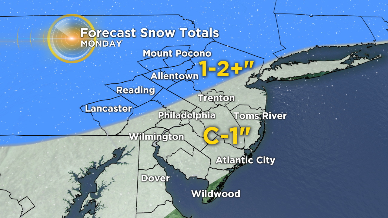
South Jersey and the shore points are expected to see a coating to one-inch tops.
As you head north into the Northern Lehigh Valley and Poconos we could see as much as two inches or locally slightly higher.