Wintry Mix Hits Delaware Valley
Follow CBSPHILLY Facebook | Twitter
PHILADELPHIA (CBS) - It has been a while since legitimate snow has fallen across Southeast Pennsylvania and South New Jersey. That is likely to change this week, as a burst of snow that could be heavy in spots will push through starting on Tuesday afternoon and evening and lasting through the overnight hours into Wednesday as well. This system will likely be leaving behind a measurable amount for many across the region.
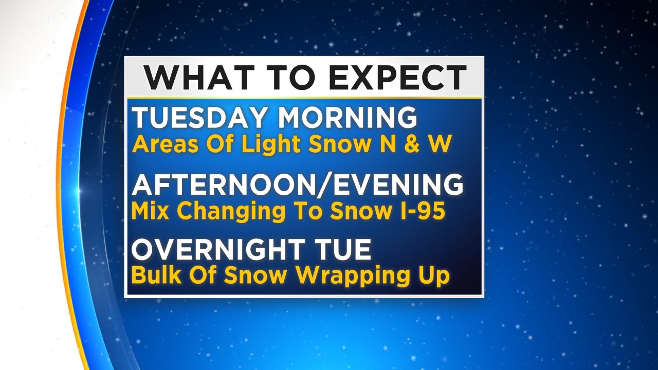
Wintry precipitation is likely to start falling as early as Tuesday morning in areas north and west of Philly. We should see snowflakes flying as early as 7 to 9 a.m. in places like the Lehigh Valley and the Poconos. A few light pockets of rain or a rain/snow mix could be possible as early as 10 a.m. in Philly and along the I-95 corridor, but, in general, most of the precipitation should hold off in Philly until about noon. The precipitation will become more widespread and pick up in intensity as we progress throughout the afternoon, with the heaviest burst of precipitation in Philly likely coming in the afternoon and evening hours, with light lingering precipitation lasting through the night until about midnight or 1 a.m. for Philly and slightly later across South Jersey and the Shore points. By the time we are waking up on Wednesday morning, it should be dry, save for a few light lingering flurries or a passing lingering snow shower in communities north of Philadelphia.
The types of precipitation with this storm system are a bit tricky but definitely not as troublesome as some storms can be. This system is playing out to likely be only a snow maker for areas north and west of Philly, meaning that as you head into the far north and west suburbs and then into the Lehigh Valley and Poconos especially, snow amounts will likely be the highest. Across the I-95 corridor, due to temperatures being a bit warmer, we are more likely to see areas of rain or a rain/snow mix in the early parts of this system in the early afternoon, before a transition in the second half of the afternoon and evening hours to all snow across a vast majority of the region. Once the transition to all snow happens, expect a quick burst to allow snow accumulation, at least a little in areas in Philly and the immediate suburbs, with just some light and lingering snow showers or flurries to persist through the nighttime hours.
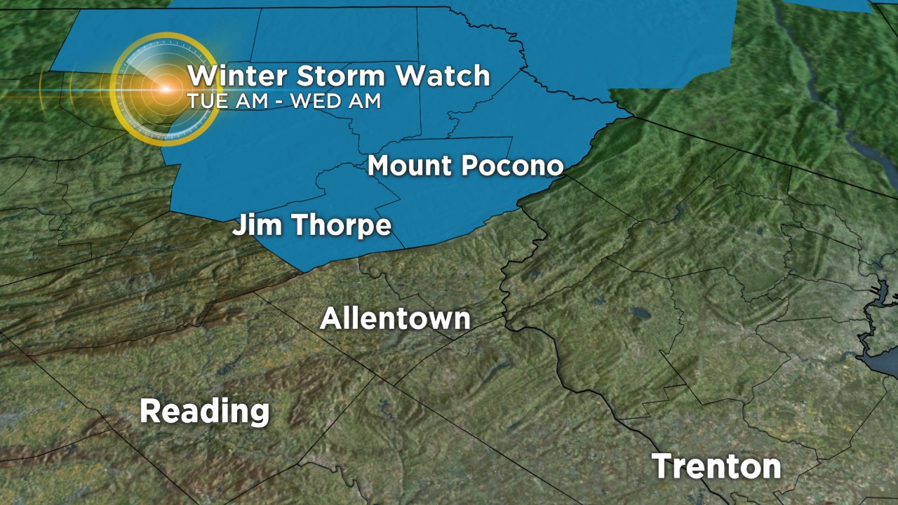
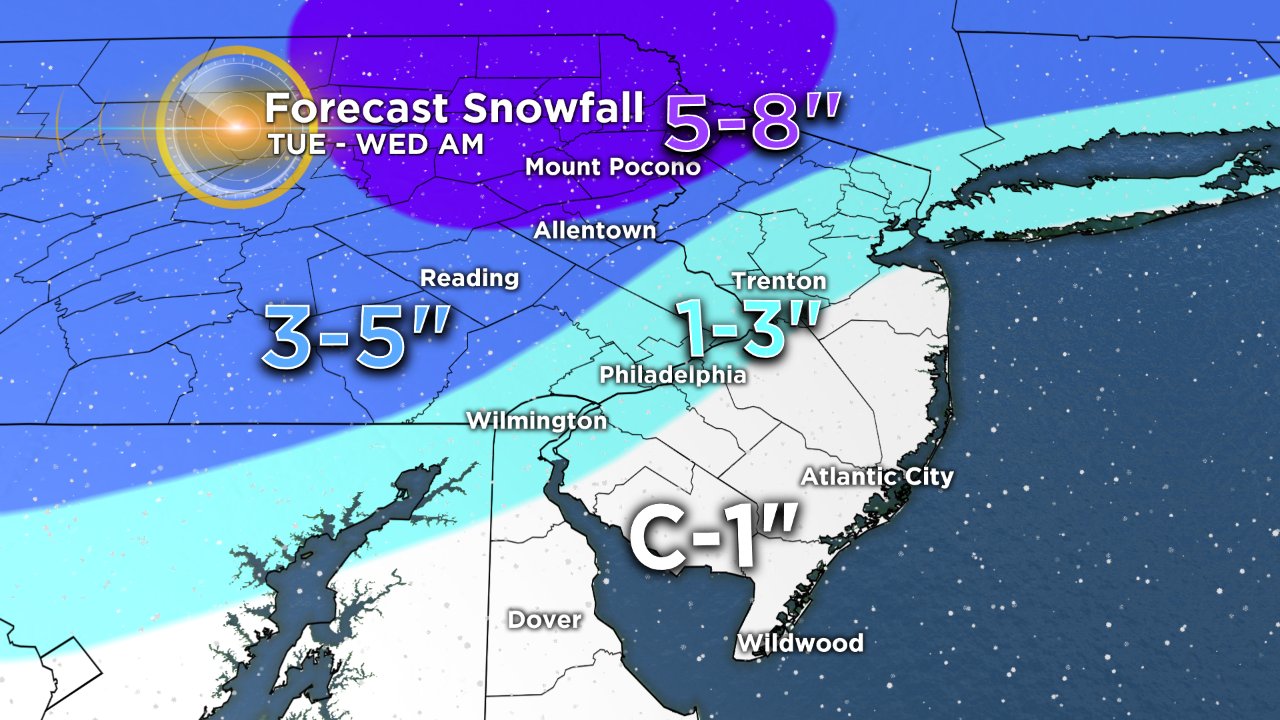
Thanks to temperatures that will remain cold enough the entire time, the highest snow totals will fall from the far north and west suburbs up through the Lehigh Valley and into the Poconos. We are expecting a wide swath of 3 to 5 inches of snow across the Lehigh Valley, with the Poconos looking at 5 inches, to locally as much as 8 inches of snow in spots. Expect travel issues starting as early as Tuesday morning in the Poconos and lasting through Wednesday morning, and a winter storm watch has been issued and will last from 7 a.m. Tuesday until 7 a.m. Wednesday. Due to the fact that we are likely to see some mixing before the change to all snow in Philadelphia, we are looking at lower amounts, generally in the 1- to 3-inch range, with Philly closer to the 1-inch side of the range than the 3-inch side of things. Finally, across most of South Jersey, Delaware and Shore Points, there is the best chance for rain to start out the vent before a brief change over to snow through the overnight hours into Wednesday. Due to the limited chance for sustained snow to fall, we are looking at only slushy coating to maybe 1-inch for areas southeast of Philly.
Either way we are likely looking at some tricky travel late on Tuesday and then again on Wednesday morning. Make sure you are staying up to date on the storm with the Eyewitness Weather Team as the system evolves.