First Of 2 Winter Storms Arrives In The Delaware Valley
Follow CBSPHILLY Facebook | Twitter
PHILADELPHIA (CBS) -- Two winter storms are set to push through the region starting tonight and another over the coming weekend. Each will have its own effects on the region, with the stronger of the two systems coming on Saturday night into Sunday.
Let's start with storm No. 1 that rolls through the area during the overnight hours tonight. We should start to see some light snow in the north and west areas as early as 8 p.m. to 9 p.m., which is good news in the fact that the evening commute on Thursday should be done before the bulk to snow starts to move in.
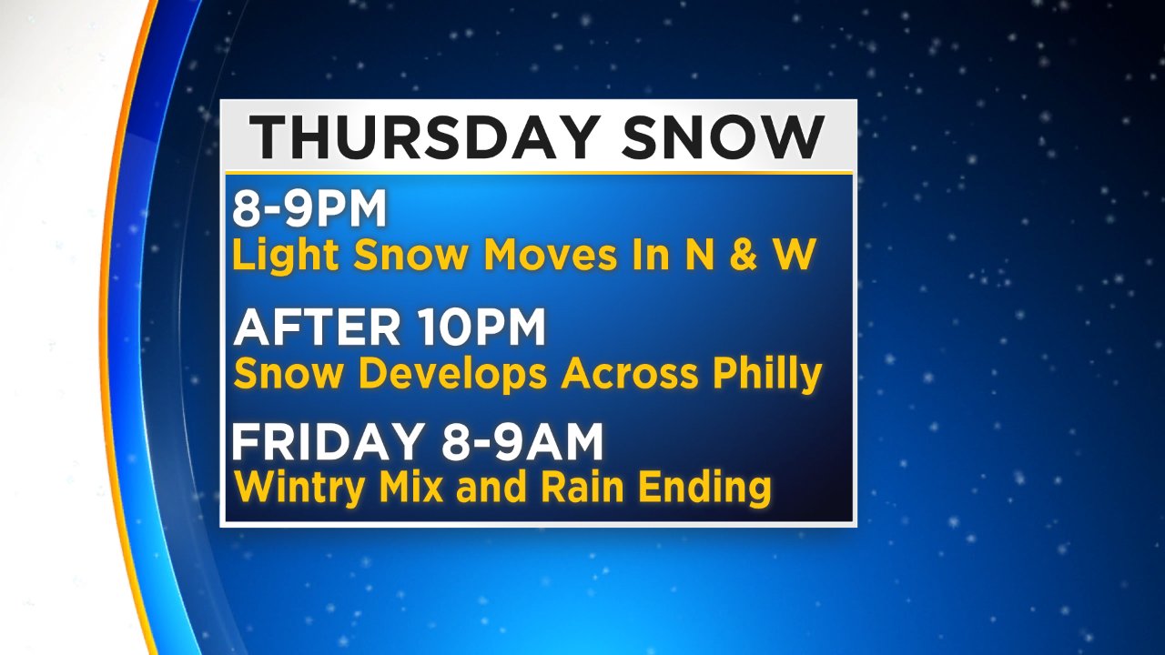
The precipitation then moves into the Philly areas around 10 p.m. before overtaking the whole region shortly thereafter. Temperatures with this storm will be slightly cooler than what we see over the weekend, but the overall system is much weaker, so snow amounts and precipitation tonight and into early parts of tomorrow morning should be relatively light.
Road Crews Ready For Back-To-Back Winter Storms
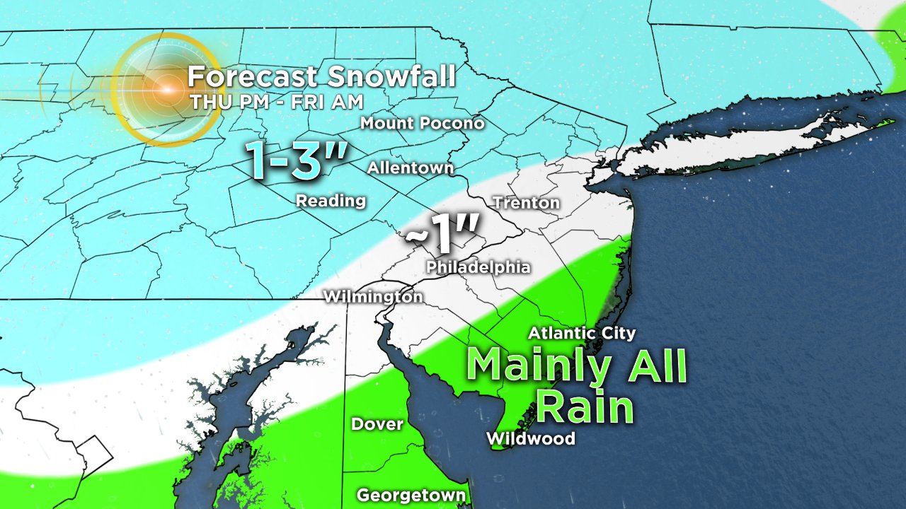
Along I-95 in both Pennsylvania and New Jersey, we should look for an all snow event but a very wet snow thanks to temperatures that are hovering near the freezing mark all night. Overall, in Philly and the immediate suburbs in Pennsylvania and New Jersey, we should look for about 1-inch of wet slushy snow to accumulate.
As you head north and west of the city, the temperature profile should remain cooler and we should see generally 1 to 3 inches of snow accumulation from upper Bucks and western Chester and Montgomery Counties, northward into the Lehigh Valley and Poconos. Temperatures in South Jersey and Delaware will generally be above freezing during the duration of the this storm, so while a brief period of slushy wintry mix is possible right at the beginning across southern New Jersey, we should see a quick change to all rain from all areas, meaning there should not be any accumulations at all if you are southeast of Philadelphia.
While this system is not overly impressive, we should still watch for tricky travel on Friday morning during rush hour and there is likely to be some delayed school openings, especially north of Philly, where high snow totals are more likely. This first system should exit the area through the early morning and we will likely dry by 8 a.m. to 9 a.m. Friday, and we could see some slivers of sunshine actually break through the clouds at times in the afternoon.
The second storm system over the weekend is the stronger of the two, but is also a bit harder to pinpoint when it comes to actual effects of the storm.
At this time, the timing of the worst of the system is pretty consistent and we should see precipitation move in through the later afternoon on Saturday, with the heaviest of the precipitation coming overnight on Saturday into early Sunday, before the system will exit off to the north through the mid-afternoon hours on Sunday and clear us out heading into the evening and then overnight on Sunday into Monday.
Due to the fact that the track of the storm is not totally hammered down just yet, the types of precipitation and the amounts of precipitation we are likely to see are still up in the air. That being said, the general gist of what we are looking at over the weekend is the system, that at the onset, should be cold enough for periods of snow or wintry mix to pop up across the entire region. The areas that are more susceptible to the snow chances early on will be north of the city, with better chances for mix and even just plain rain from the city on south and east.
SCHOOL CLOSINGS/ DELAYS
Throughout the event, but more specifically on Saturday night, warm air will start to creep into the region from south to north, and as this happens, we will see the precipitation likely change from a more frozen variety of precipitation to plain rain for much of the area. As the low then progresses farther from the area on Sunday, cold air will rush in on the back side and if there is enough moisture still hanging around the region, we could see another change over back from the plain rain to a more frozen type of precipitation before the system totally clears out of the area.
Due to the changing temperatures and precipitation types over the weekend, some icing could occur, especially in areas through the Lehigh Valley and north into the Poconos, so power outages will be a concern for us moving forward toward the end of the storm this weekend, as winds will also be picking up and potentially gusting very high on Sunday afternoon into the evening hours as well. Temperatures will then plummet on the backside of the departing low and we could see some flash freezing across all of the region as drop into the single digits or even below zero in areas by Sunday night and then into Monday morning as well.
Make sure to stay with the Eyewitness Weather Team throughout the next few days to keep updated on the impending Winter Weather. Also you can stay up to date 24/7 on CBSPhilly.com and by downloading the CBS Philly Weather App.