Why Are We Getting Extreme Rainfall This Summer?
Follow CBSPHILLY Facebook Twitter
PHILADELPHIA (CBS) — The Delaware Valley is again under a risk for localized flooding today as downpours and thunderstorms develop across the area.
Monday morning, numerous water rescues were conducted across Delaware, Chester, and Montgomery counties as many locations received a month's worth of rain in a matter of hours--not to mention the 3-5" of rain received by our western suburbs on Saturday.
Extreme precipitation events, and resulting the flash flooding threat, seem to be the reoccurring trend of this summer...but why? The answer may point to the increasingly observable influence of global warming.
The science behind this is fairly simple; warmer air is capable of holding more water vapor. For each degree of warming, the air's capacity for water vapor goes up by about 7 percent. Thus an atmosphere laden with more moisture is capable of producing more intense precipitation-- this is what has been and continues to be observed.
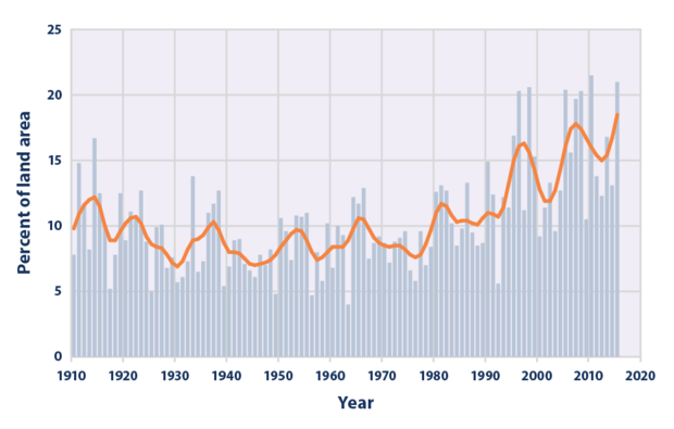
Since 1990, the prevalence of extreme single-day precipitation events has substantially increased.
The figure below shows the percentage of the land area, of the lower 48 states, where a much greater than normal portion of total annual precipitation has come from extreme single-day precipitation events.
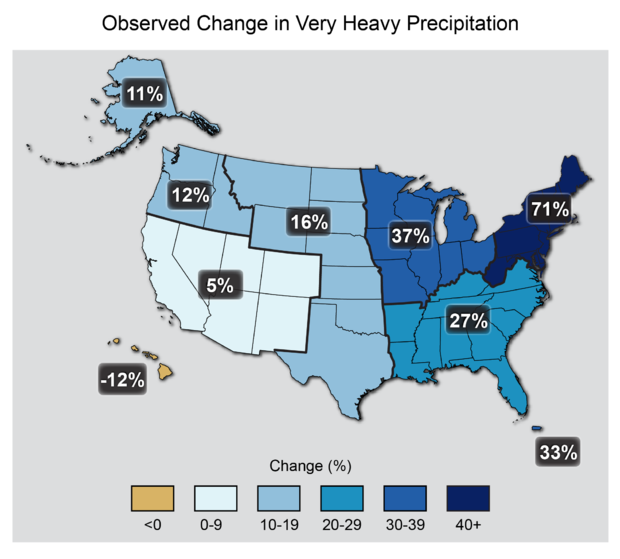
Not only is extreme rainfall happening more often, the rain is also becoming heavier during these events. And the most marked increases have been observed in the Midwest and here in the Northeast.
The map below shows the percent increases in the amount of precipitation falling in extreme rain events (defined as the heaviest 1% of all daily events) from 1958 to 2012 for each region of the continental United States.
More frequent extreme rainfall events yield not only the threat of flash flooding but have a number of consequences on public health and safety including the degradation of water quality.
Stormwater run-off often includes pollutants like heavy metals and pesticides, that can end up in local streams, rivers, and lakes, thereby lowering water quality for human uses as well as compromising aquatic ecosystems.
And not only does this signal of climate change appear in the summer months, in the winter, snow storms could likely become snowier in a warming world, also due to the increased availablity of atmospheric moisture.