Tracking Severe Storm Potential On Wednesday
Follow CBSPHILLY Facebook Twitter
PHILADELPHIA (CBS) - After a rainy pattern that seemed to never end and another wet and unsettled weekend finally gone from view, we look at some drier and sunnier days ahead. Today looks close to perfect with sun and temperatures in the mid 70s, but we aren't out of the woods just yet. There is a chance for showers and a few isolated severe storms Wednesday afternoon and evening.
The frontal system that will become our weather maker for the next 24 to 36 hours starts to make its way into the Delaware Valley as we head into the overnight hours tonight. We can expect temperatures tonight to stay relatively mild with humidity on the rise which will feed a few spotty showers.
This theme of scattered shower and thunderstorm activity will be one that carries through the day on Wednesday. Due to multiple frontal passages that will take place throughout Wednesday, the necessary ingredients are there for a strong or potentially severe thunderstorm to fire up across the region.
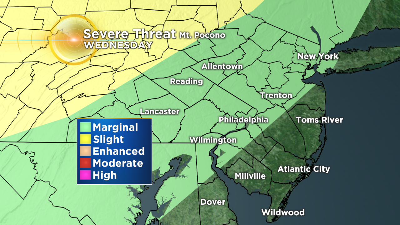
The Storm Prediction Center has issued a marginal risk for a majority of the area on Wednesday. The exception to this is South Jersey and the shore. The greatest risks with these stray severe thunderstorms late in the day will be isolated heavy downpours, gusty winds, and the potential for flash flooding.
The threat that we are most concerned with out of those mentioned is the potential for flash flooding. This is due to the ground being over-saturated thanks to the heavy rain we have seen in the seven of the 11 days so far this month. If you are caught in a heavy downpour you can expect excessive runoff due to the fact that the ground can't absorb all of the water. This will lead to swelling of creeks and streams, flooding in areas of poor drainage, and for the potential of trees with shallow root systems to collapse.
Throughout the afternoon there is a potential for pop-up showers and thunderstorms because of the hot and humid conditions. The cold front will begin to move in around 6-7 p.m. The first areas affected will be north and west of the city, mainly in the Lehigh Valley and the Poconos. The strongest of the thunderstorms should begin to move into the Philadelphia metro area by about 9 p.m. As the front moves through Philly and into South Jersey, it will begin to break apart and these scattered thunderstorms will clear the coast by midnight.
This is a fluid and evolving situation, so make sure you are staying up to date with the forecast by staying with the Eyewitness Weather Team. You can get your forecast all the time on CBSPhilly.com, our CBSPhilly Facebook page and by downloading our CBSPhilly Weather App.