Brief Shot Of Cold Air To Start Winter Followed By Another Warm-Up
PHILADELPHIA (CBS) -- Last week gave us the impression that winter may start out pretty harsh across the Delaware Valley, but just like that, Mother Nature has thrown us a curve ball and we were dealing with very mild air sitting over the region to start out the most recent work week.
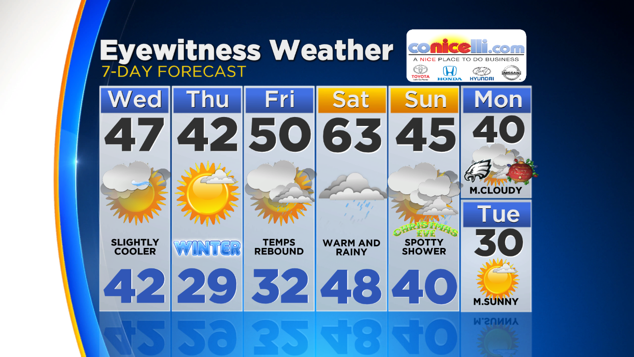
Tuesday ended up being almost 20 degrees above normal in a few spots through the area, and while Wednesday and Thursday (the official start to the winter season) are going to end up seasonable for mid/end of December, another dose of mild air is likely to warm us as we head into the Christmas weekend.
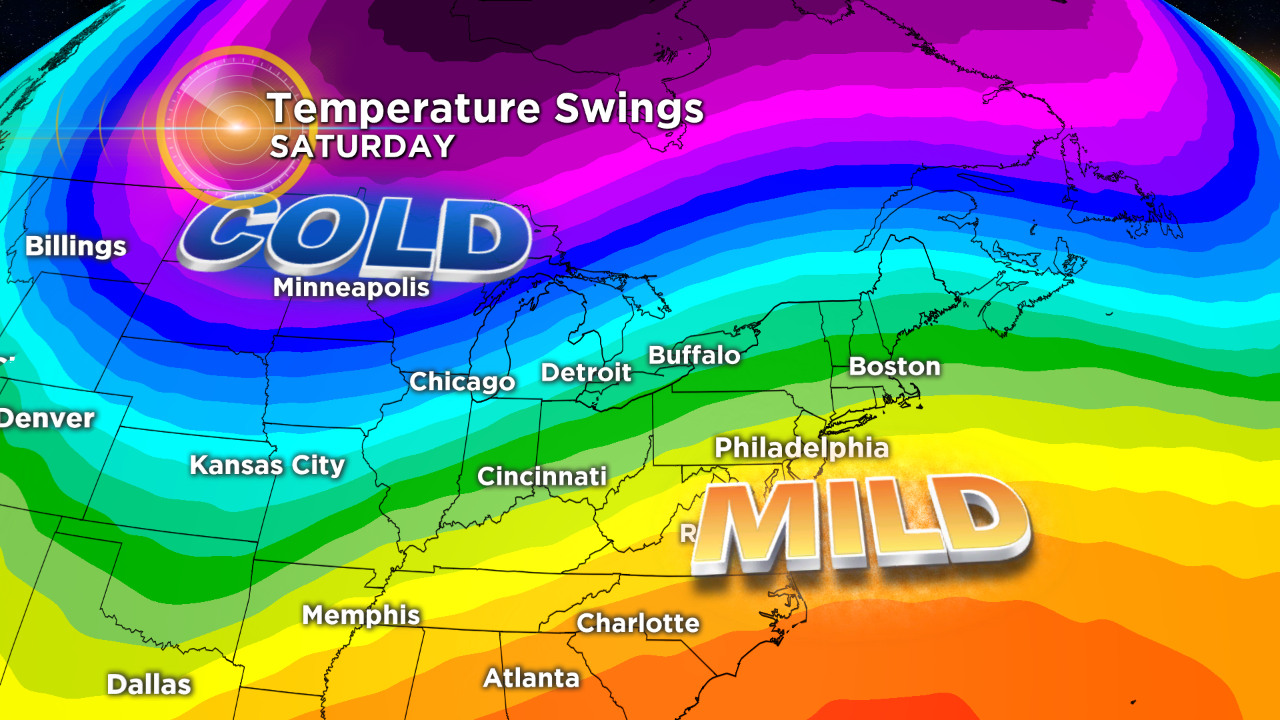
The warmest air that we are likely to experience in the next four to five days is going to flow into the region starting on Friday on the back of southerly winds in front of a strong area of low pressure that will dig into the Midwest starting on Friday morning. Temperatures in areas across the Midwest are likely to only peak in the teens and 20s to end the work week.
The deep trough that develops to our west means a strong ridge of high pressure will form to our south and pump in that warmer air. This will allow highs in the area on Friday to climb into the lower 50s in spots, while we peak in the low 60s on Saturday!
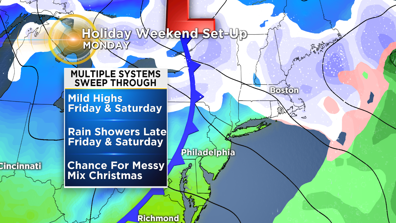
The strong trough pulling in the cold air for the Midwest then starts to propagate eastward starting on Friday and we could see a few spotty rain showers as early as Friday night. The surface low associated with the trough pulls in the Northeast on Saturday with plenty of moisture. We should be looking at a generally washed out Saturday with rain likely all day across the whole region.
While many people might not be happy about the warm December weather, it likely saves us form a dumping of snow at this point, since if it was colder, the rain we are likely to see Saturday could have potentially been all snow. As it stands right now most of the rain will finish up on Saturday evening and Sunday morning, leaving us with a cooler and likely dry Sunday.
Christmas on Monday is a bit more of a cloudy scene at this point. Most of the mainstream weather models are going back and forth on the chance for precipitation on the holiday itself.
As of right now it appears as though there is a chance for some kind of precipitation to fall on Monday, likely in the morning hours. However, we are concerned with the positioning and timing of the potential system as it passes off the coastline. A jog east or west or a slowing down or speeding up of the system could change the forecast drastically.
As of Wednesday morning it looks as though we could have some areas of rain showers with a chance for a bit of wintry mix or snow flakes north and west of the city while the rain will be confined to areas to the east of I-95. Again, there is a decent amount of uncertainty so make sure to stay with the Eyewitness Weather Team for any and all changes to the forecast in the coming days.
Have a great Wednesday!