Weather Roller Coaster Continues This Weekend And Into Next Week
PHILADELPHIA (CBS) - If you cannot tell that we are starting to work our way toward the end of the Winter season and into the transition zone as we start Spring, you must never step outside.
Temperatures have been back and forth for the last week, with highs peaking yesterday in the 60s and then a chance for snow this coming weekend. We will breakdown the snow chances and then another opportunity for temperatures near 70 in today's blog update.
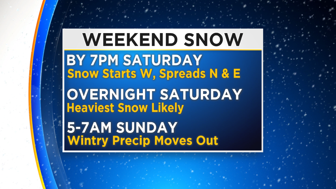
The weekend system that brings the snow to the region has finally come into slightly better view as we move into the 36 hour out range of the forecast. Model agreement on timing has been good through the last couple runs and right now that means we are looking at an event that kicks off to the west of Philly in the later afternoon and evening hours.
The precipitation will then become widespread over the whole region through the night on Saturday into the early morning hours on Sunday. In general the system is going to keep all snow to the north and west of Philly with mainly just rain in areas along the shore in South Jersey and into Delaware. The biggest area of concern is where the split will occur for the rain to snow change over, and unfortunately that looks to fall right over the I-95 corridor and Philadelphia itself. While there is a chance for a rain/snow mix across the metro area on Saturday night, the main precipitation type at this time looks like a sloppy and slushy wet snow for Philly. The messy mix of Wintry Precipitation begins between 6-7PM on Saturday evening for areas to the west of the city.
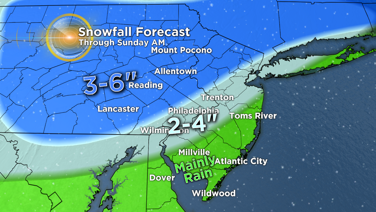
It should overtake Philly by the early overnight hours and whole region throughout the rest of the night. Due to the fast-moving nature of the system, it will likely be gone by the time we ht the daylight hours on Sunday morning. In the wake of the system we will have a decently wide range of snow totals and precipitation types as well. Along the coastline in Jersey and into the Delaware temperatures should remain warm enough that this event ends up being a purely rain situation.
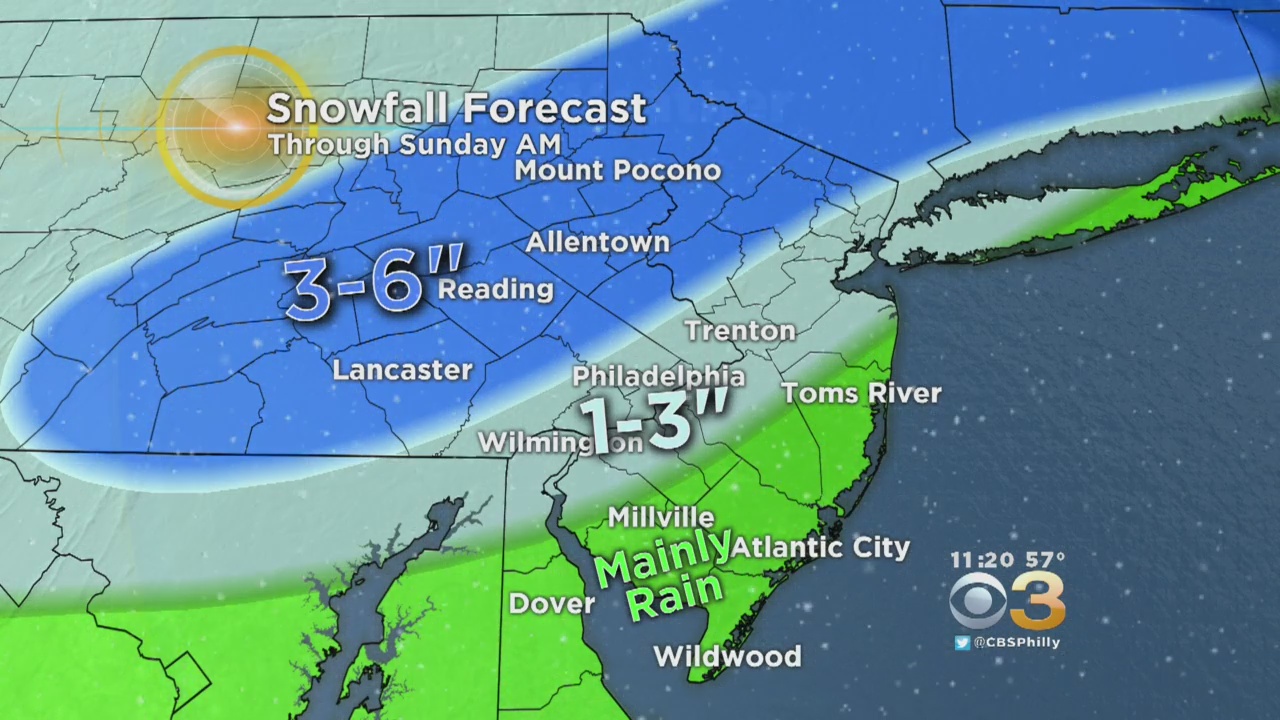
However, there is a small chance for a little it of wet snow to mix in but it should not be enough to even really cover any surface. Moving farther inland to the Philly area, we see amounts ramp up thanks to temperatures that will be cooler for longer. There is a small chance we could see a period of mixing with rain, snow, and possibly sleet before the snow takes over,m but that period of mixed precip will be very short lived. Snow amounts in the Philly area and along the I-95 corridor are likely to be in the 2-4" range. That 2-4" we are predicting will be a slushy, and messy mix, so do not expect a nice pretty Sunday morning with fresh snow when you wake up. As we work farther north and west away form Philly the temperatures are again cold enough that we see a purely snow event.
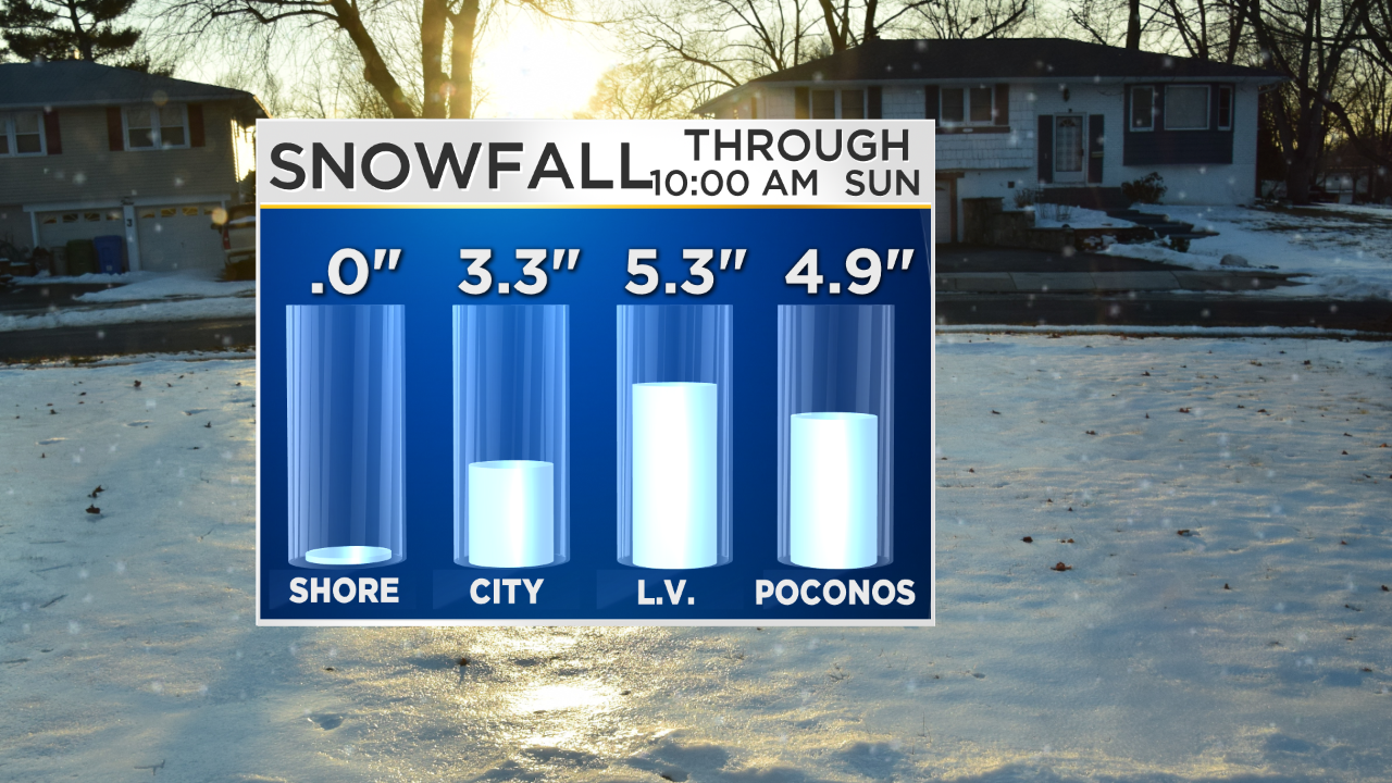
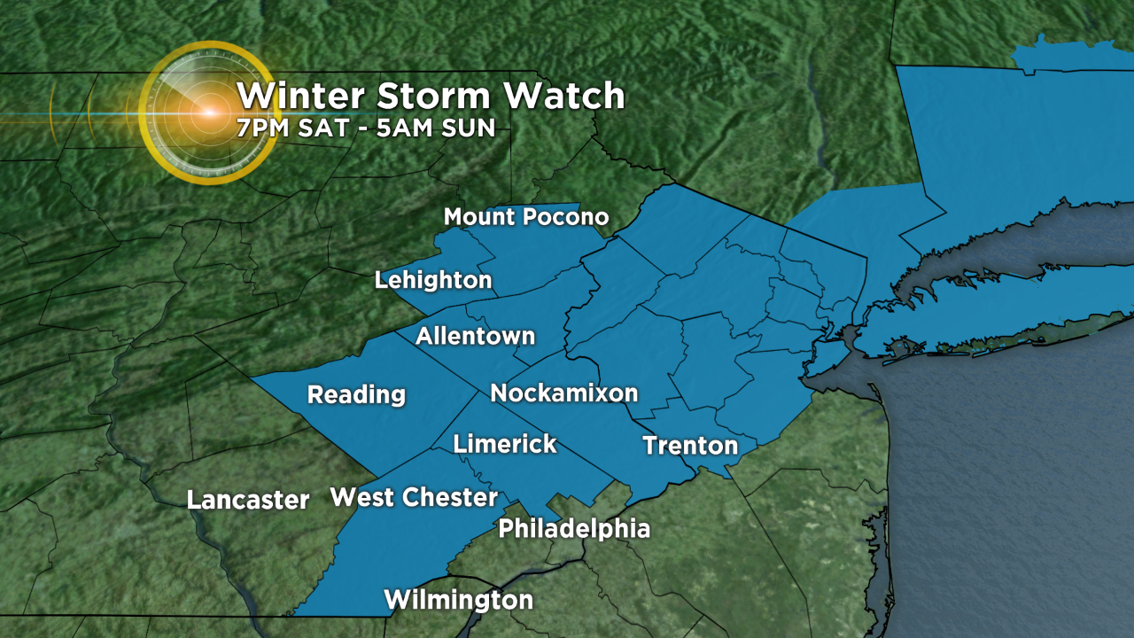
The Lehigh Valley and Poconos are looking at the highest snow total with this system. Amounts could be as high as 3-6" in areas before Saturday night is over. Due to the fact that snow amounts will be decently high and the chance for difficult travel will be out there on Saturday night and early Sunday morning, the National Weather Service has issued a Winter Storm Watch that will go into effect on Saturday at 7PM until 5AM Sunday.
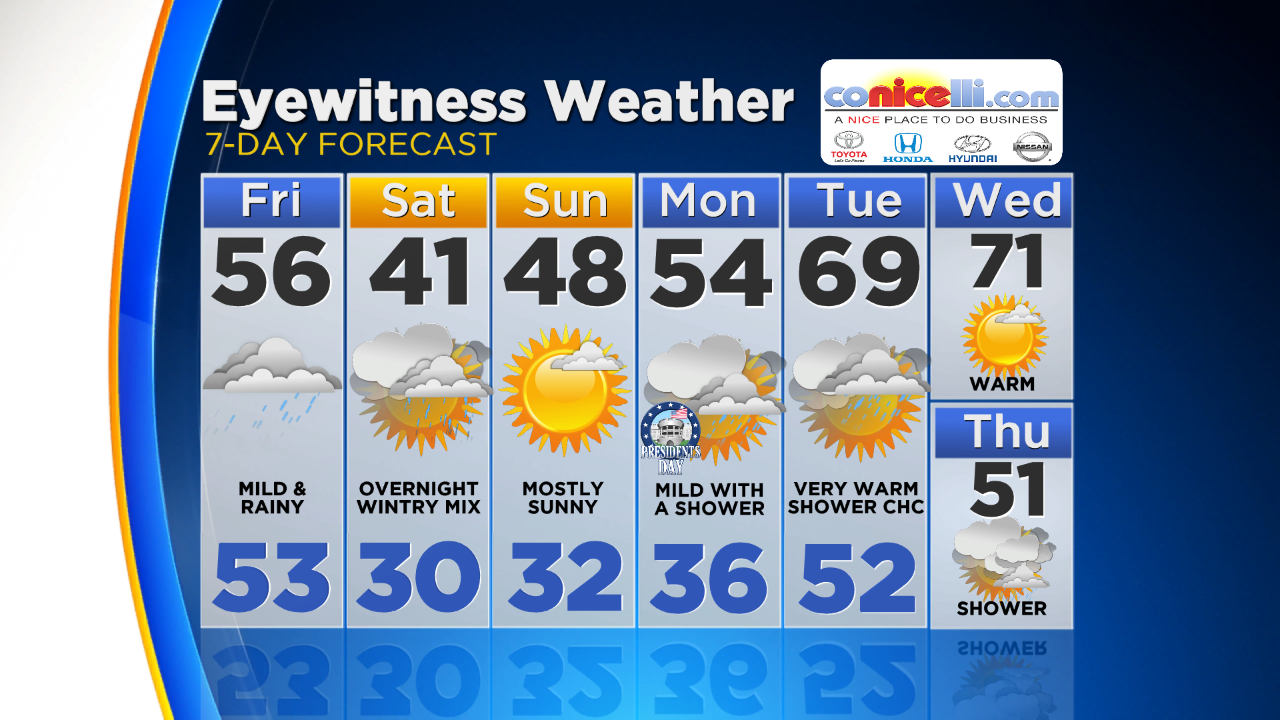
Mother Nature then throws another twist into the forecast after this messy weekend, as temperatures rebound on Sunday back into the upper 40s to near 50 so any snow is likely to melt quickly and by the middle of next week we could get another taste of Spring time as temperatures on Tuesday and Wednesday could be as high as the upper 60s to near 70!
Have a great weekend and make sure to stick with the Eyewitness Weather Team all weekend for your up to the minute weather forecast!