Weather: In Depth Winter Weather Outlook For Our Region
PHILADELPHIA (CBS) -- With Thanksgiving right around the corner and a chill in the air, everybody is starting to think about winter. And of course, the question on everybody's lips is "how much snow are we going to get?"
It's interesting to think about this. It's the one weather phenomenon where meteorologists are asked to predict a finite amount of something over the course of an entire season. Nobody would ask us to predict how much rain would fall in the summer or what the exact average temperature will be for next spring, but winter snowfall is a different story. That's because snow impacts SO much of our daily lives. It can shut down the whole city, close schools and businesses, and lead to very dangerous driving conditions.
So, with that said, how much snow are we going to get? This year, our projection is for a normal or slightly below normal winter (normal is around 22"). Our projection is 18-24". But before you stop reading, I'm going to explain how we got to that number, and it's very different than the past couple of years.
You may have heard about the "Godzilla" El Nino in the Pacific Ocean. An El Nino pattern occurs when trade winds push warmer than average water toward the west coast of South America, leading to anomalously warm sea surface temperatures (SSTs) in that region.
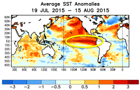 This year's El Nino is one of the strongest we've seen in many years. In fact, it recently set a weekly record for the highest average SST in one particular basin (3.4, which is the standard measurement point). Now, that's not generally how we measure the strength of an El Nino. Instead, we look at something called ONI, which is basically a three-month average. So we'll only really know the strength of this particular El Nino once it's over. However, almost all forecasts keep this El Nino at least in a Top 3 strongest position through at least the first half of winter, with a very gradual weakening in the spring.
So what does this mean? Well, first and foremost, we have data set issues. There have only been two recorded El Ninos of a similar strength to this one, as we only have records dating back to 1950. These two winters were 1997-1998, currently the strongest recorded El Nino winter, and 1982-1983.
So we should be able to just look at those two winters and figure out what this winter will do, right? Not so fast.
1997-1998 was a very warm winter and featured LESS THAN ONE INCH of snow all winter. 1982-1983? It was a warm December, but a few strong storms timed out well with shots of cold air to deliver so heavy snow - in fact, the blizzard of '83 dropped 21.3" of snow in Philadelphia on Feb. 11-12.
You can see there's quite the spread there. And that's true of all our El Nino winters on record - snowfall amounts are all over the place, from 0" to 78.7" (that's right, the winter of 2009-2010 was a moderate El Nino winter, which was also preceded by a warm November).
There also has to be some consideration to the type of El Nino present. We look at where the concentration of the highest SST anomalies are located to determine the type of El Nino. There was some talk early in the season about a "Modoki" El Nino developing - this pattern has very warm water in Nino 3.4, but much colder water on either side. It's looking as though that won't be happening - while the warmest SST's ARE concentrated in Nino 3.4, the anomalies are still quite pronounced on either side, though not as strong as 1997-1998. So it's looking like this year will be a bit of a hybrid El Nino, or central-based.
This is interesting, however, because remember both of those strong El Nino winters we talked about above? Those were both traditional, east-based El Ninos. So we don't have a record for a winter like this one, a very strong central-based El Nino. We do know, however, that central-based El Ninos tend to bring snowy conditions to the northeast. The last central-based El Nino we've had? 2009-2010 again.
So. This is the thing to keep in mind with El Nino - it's a pattern of extremes. El Nino winters tend to be warmer and stormier, on average, thanks to a split flow in the jetstream. This allows warm moist air from the Pacific to invade, but also provides a path for storms to travel from the Gulf up the Eastern Seaboard, i.e. nor'easters. The key is observing whether these potent storms match up with the relatively limited bursts of cold air that manage to overcome the warmth. Clearly, in 1983, the storms found enough cold to make a difference. In 1998, they did not.
While El Nino will be the main driving force behind this winter, it's not the only thing we look at. I'll briefly (ha, briefly for me) run down a few of the others.
An important climactic feature is the NAO, or the North Atlantic Oscillation. A negative phase of the NAO is associated with below-average temperatures in our region, meaning if you combine the strong El Nino stormy pattern with the negative NAO cold pattern, you could get big snow. However, the NAO is highly variable and only really predictable out two weeks out.
We also tend to look to Siberia to assess the early-season snowpack. While not as impressive as the past two years, it's still significant. A more extensive snowpack in Siberia tends to negatively impact another teleconnection known as the AO, or Arctic Oscillation. A negative phase of the AO tends to mean a greater chance of cold air outbreaks making it to the Northeast. It's definitely something to consider, although again, not as pronounced as last year.
Last year we also saw a strangely warm bubble of warm water in the north Pacific Ocean. This warmth may have aided in setting up the blocking pattern we suffered through last year - persistent western ridging and thus, eastern troughing leading to persistent, deep arctic cold.
There are several other factors that will influence our winter - the PDO is in a positive phase, which may enhance the impacts of Nino, for example, plus the PNA, MJO, etc. But while these are all players on the field, the strong-very strong El Nino is the quarterback for the winter of 2015-2016.
So what's the takeway? The TL;DR version, if you will?
I know I gave you a snowfall projection at the very start of this post. But if there's any message I want to get across clearly, it's that a seasonal snowfall projection is just that - a projection. And even though our projection puts us around "average", hopefully what you just read clearly gets the message across that this winter is ANYTHING but average. We are dealing with a very extreme, high-variability pattern this winter. There's just as much of a chance that we end up under 15" as over 35". It all depends on whether the storms time out with the cold, and that's a nowcast situation, not a long-range one.
Our projection of 18-24" assumes a very warm start to winter, and then a handful of larger storms that could produce over 6" apiece. With cold air being a little harder to come by this winter, we won't be dealing with the parade of small but frequent storms and clippers that brought 2013-2014 into 2nd place on the snowfall records list. But, as with 1982-1983, if we get one major storm that produces 20"+ inches, there go all the predictions. It's just impossible to know until the storm forms.
Temperature-wise, all indications are that the first half of winter will feature above-average warmth, with the chance at several short-lived cold shots. As the El Nino begins to weaken late in the winter, February into early March will bring the chance at more frequent cold spells, which of course also increases the chance of big snow.
Also want to mention that the presence of warm air and a stormy pattern may lead to what we call p-type issues. That is, storms that start as rain, then mix over to a slushy, icy mess, etc. Our threat of a major ice storm is greater this year than in years past, thanks to this particular pattern.