Philadelphia Wild Weather: Severe Thunderstorm Threat Wednesday Gives Way To Return To Winter
PHILADELPHIA (CBS) -- Temperatures crossed into the 70s Tuesday for the first time in 10 days. It'll be mild, breezy, and uneventful tonight, before a quick-hitting system brings the threat of severe thunderstorms to the region, followed by a swift and significant temperature drop that will usher in a short-lived return to winter.
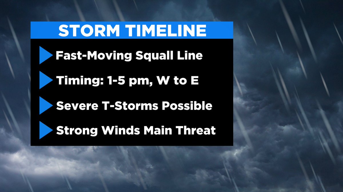
A fast-moving cold front will race across the Delaware Valley Wednesday afternoon. The entire area is currently under a Marginal Risk (1 out of 5) for severe weather. The main threats are damaging winds, frequent lightning, and brief, heavy rainfall.
Tomorrow starts off with little fanfare and likely mostly sunny skies, though we can't rule out a few isolated pre-frontal showers.
Then, in the afternoon, model data continues to indicate that a squall line, or line of strong thunderstorms, will drive across the area. Timing looks to be from 1 p.m. to 5 p.m., from west to east.
Center City timing looks to be around 2 p.m. to 3 p.m. The storms should be moving offshore by 5 p.m., prior to the height of the evening rush.
Expect skies over your neighborhood to clear straight away following the passage of the squall line.
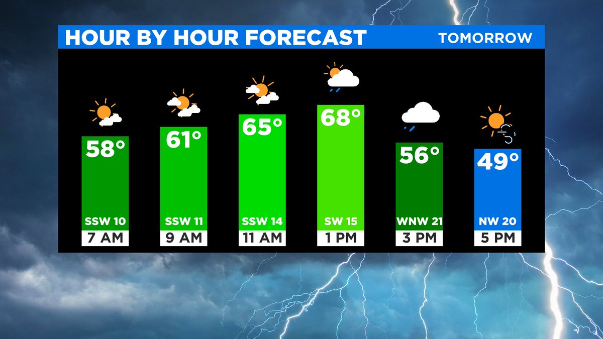
Additionally, be sure to pack the winter coat when heading out tomorrow morning as conditions will feel dramatically different by the time you head home. Behind the frontal boundary, temperatures will immediately and rapidly plummet tomorrow afternoon.
Many locations will fall from near 70 degrees to the mid-40s in one to two hours. Gusty winds will also kick up to yield wind chills in the 30s across much of Pennsylvania by 8 p.m. tomorrow evening.
And though most of us will see thunderstorms, the Poconos may also experience snow squalls and/or convective showers capable of producing brief, freezing rain.
Additionally, I would not be shocked to see a few flurries, or an isolated snow shower tries to sneak into the Pennsylvania suburbs tomorrow night as unseasonably cold, Canadian air continues to spill in across the region.
 Though we will mainly be spared from any wintry-type precipitation, this same storm system is set to bring 6-plus inches of spring snow to parts of Upstate New York and New England.
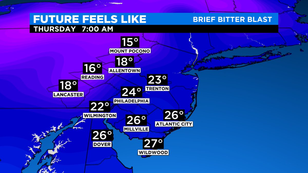
Lows will fall into the 30s region-wide tomorrow night, and the combination of blustery conditions will prompt wind chills in the 20s across the area by Thursday morning, and wind chills in the teens are likely in the Poconos and Lehigh Valley, eek.
High temperatures struggle to low 50s Thursday afternoon, and with wind gusts to 40 mph, it will feel like 30s and low-40s for most of the day.
We quickly return to more spring-appropriate temperatures by Friday afternoon with highs in the mid-60s.