Pennsylvania Weather: Ice Storm Warning Issued For Parts Of Delaware Valley For 1st Time In 10 Years
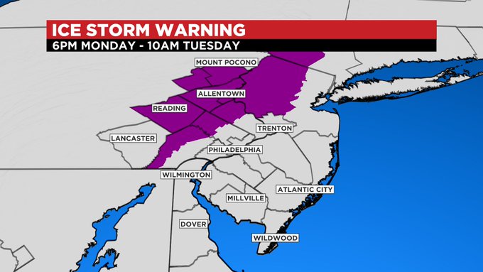
PHILADELPHIA (CBS) -- A significant icing event is set to materialize for parts of the area Monday night into Tuesday morning. An Ice Storm Warning has been issued for our far north and west suburbs, the Lehigh Valley, Berks County and the Poconos from 6 p.m. Monday until 10 a.m. Tuesday. The National Weather Service has not issued an Ice Storm Warning issued for any part of our area in 10 years, since February 2011.
Some patchy areas of freezing drizzle, light rain or light sleet are possible tonight as a preceding area of low pressure passes offshore. Some localized minor ice accumulation possible by daybreak. Then, our main event next storm system that will bring multiple hazards to the area, including heavy icing, heavy rain, gusty winds, and possible wintertime thunderstorms, quickly approaches.
Throughout most of Monday, areas of light freezing rain and/or light sleet are possible, with a snow mix chance to the north and west. Through Monday evening, precipitation will become more widespread and pick up in intensity.
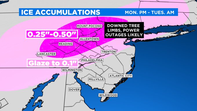
For the Philadelphia and near-by suburbs, particularly in Pennsylvania, this starts as freezing rain, and this is when the city could pick up a glaze to potentially 0.10 inches of ice. A Winter Weather Advisory is in effect for Philadelphia and nearby Pennsylvania, Delaware and New Jersey suburbs.
The major concern is for areas far north and west, under the Ice Storm Warning, where precipitation may begin as a wintry mix of snow, sleet and freezing rain, and a quick coating 2 inches of snow is possible, before transitioning to all freezing rain, some of which could be heavy Monday night.
By mid-morning Tuesday, parts of western Chester, northwest Montgomery County, Upper Bucks County, Berks County, the Lehigh Valley, and the Poconos may see ice accumulations up to 0.50 inches, which is significant.
For comparison, we had about 0.05 inches of ice in Center City Saturday night, which yielded those extremely slick conditions. Travel may be difficult to near impossible, and power outages in the Ice Storm Warning area are likely. The question will be to what extent, as outages and tree damage will result from the weight of the ice alone.
Additionally, there is a concern over the potential for widespread and longer-lasting power outages in these areas, as a period of localized gusty winds may impact the region from about 4 a.m. to 8 a.m. Tuesday, exacerbating the effects of the ice.
Strong wind gusts in association with a very strong low-level overhead may mix down to the surface to produce localized gusts of 35-plus mph. Some models have these gusts concentrated over South Jersey and not extending into eastern Pennsylvania, however, others suggest this is possible.
Regardless, it appears winds will pick up region-wide behind the system to gust to 20 to 30 mph, and though while not intense, this could cause big power outage problems in areas that pick-up high-end ice totals.
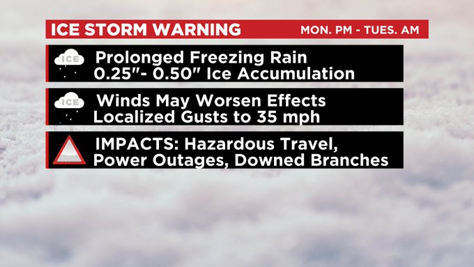
According to the Ice Accumulation/Damage Index; 0.25 inches to 0.50 inches of ice with winds of 25-35 mph, can cause numerous utility interruptions, with outages lasting 1-5 days, and excessive tree limb damage. This scenario may not come to fruition, but it is certainly a concern.
The shore is not under any watches or warnings as this will be primarily a rain event for the coast, yet the rain could be heavy at times late Monday night and early Tuesday morning, along with the possibility of embedded thunderstorms, and wind gusts to 40-plus mph during this timeframe.
Temperatures across South Jersey on Tuesday morning could climb into the mid-50's, whereas west of I-95, temperatures stay in the 30's, the cold air reinforced by a decent snowpack still in place. Any and all precipitation concludes by mid-morning Tuesday.