Philadelphia Weather: Delaware Valley Bracing For Two Storm Systems Expected To Bring Chance Of Snow
PHILADELPHIA (CBS) -- We have not had 1.0" of snowfall in Philadelphia in 651 days. That streak will end this week as two storm systems will bring a chance of snow to the region, the second of which is looking like a bit of a doozy.
The less eventful of the two systems arrives Monday and will be a bit of a mixed bag.
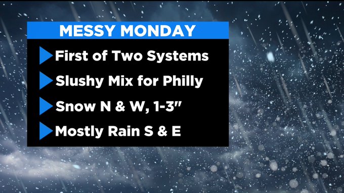
Precipitation will commence by mid-morning, and end from west to east through the afternoon. Right now, it looks as though most, if not all, of South Jersey will see primarily all rain. Though New Jersey suburbs closer to I-95 have a better shot a seeing some mixing or a brief period of all snow, regardless any accumulation will very minor.
In our far northwestern suburbs, the Lehigh Valley and Poconos all snow is likely on Monday, which may result in accumulations of 1-2+" of snow.
For Philadelphia and near-by suburbs, plan for rain and a wintry mix, though a period of all snow around midday cannot be ruled out. If this occurs, a slushy minor accumulation is possible.
Monday's system moves out by the evening and the precipitation clears off fast as well.
Tuesday will be sunny and cold with highs in the 30's.
That cold air then will remain over the region as we head into Wednesday as the next much more powerful system arrives.
Models continue to indicate that a strong Nor'easter will impact the Delaware Valley on Wednesday and into Thursday. Impacts to include heavy precipitation, strong winds and some coastal flooding.
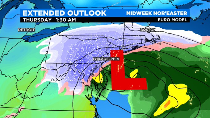
The chance for plowable snow across a large portion of the region is looking increasingly likely.
Presently, it is still too early to forecast more specific details, but significant snow totals may be possible near and west of I-95. Where the rain/snow line sets up remains a question and an important one as snowfall amounts will sharply cut off east of this line.
This will be a heavy wet snow particularly for/near the city with temperatures near freezing.
Strong winds will accompany this storm with gusts to 40-45+ mph Wednesday night into Thursday morning. This combination is likely to lead to, at minimum, scattered power outages.

Frigid conditions will prevail through this time frame as well with highs in the 30's, lows in the 20's, and very cold wind chills in the teens.
This forecast is evolving. Keep informed of changes and updates. Remember to focus more on winter storm impacts, and less on the snow totals.
Though specific details remain to be ironed out, it is highly likely that a powerful storm system will affect the Delaware Valley on Wednesday and into Thursday.
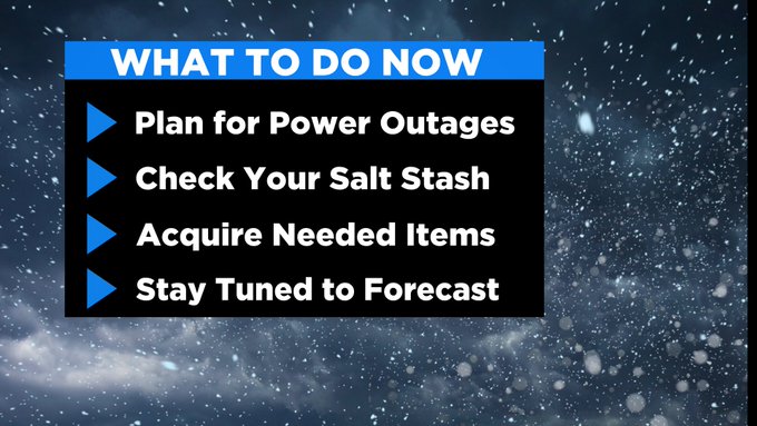
Start to plan accordingly, by preparing for possible power outages, altering travel plans is possible, acquiring needed food items and medicine for yourself, family members and pets, and share the news with your friends and neighbors of the impending active weather.
MORE ON CBSPHILLY.COM
Gov. Murphy Says 'We Are Now In Opening Scenes Of End Of This Pandemic'
FAQ: New Pennsylvania COVID-19 Restrictions Explained
COVID In Pennsylvania: New Restrictions Take Effect To Help State Combat Surging Cases