Philadelphia Weather: Wintry Weekend Before A Workweek Warmup
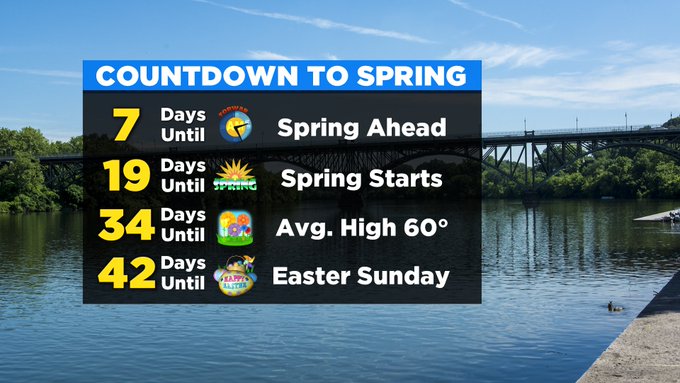
PHILADELPHIA (CBS) -- While we tend to think of March as the beginning of the end of the winter season, we still need to remember that winter does officially continue for another 19 days before spring kicks off on March 19. We also all remember the saying, "March comes in like a lion and goes out like a lamb," and to a certain degree, we will live up to the saying.
The cold and windy weather that popped up at the end of last week starting on Thursday carries through Saturday and at least to some respects Sunday too.
High temperatures on Saturday, under a mix of sun and clouds, will be very winter-like, only topping out in the 30s. When you add in the winds, it will feel like the 20s most of the afternoon.
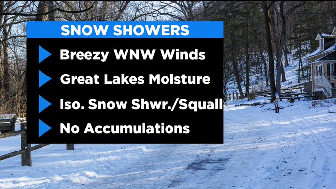
The persistent winds will actually be able to funnel in some moisture from the Great Lakes and a passing snow shower or squall are possible in the afternoon. The good news, though, is we are not expecting any snow accumulations at this time.
Temperatures will then start to climb Sunday, as full sunshine returns to the area.
Even if the breezy conditions continue across the Delaware Valley, look for highs to jump back into the 40s for March 1.
The new workweek is going to be unsettled, to say the least. We are likely to start out dry on Monday, with even some sunshine for the first parts of the day. Clouds will then increase in the afternoon and evening hours, as we wait for rain showers to develop overnight.
Temperatures will soar into the upper 50s thanks to strong southwest flow on Monday afternoon.
As multiple areas of low pressure pass by the region on Tuesday and Wednesday, the breezy southwesterly winds will continue to pump in mild air and temperatures Tuesday and Wednesday.
Temperatures in the afternoon will rocket into the low to even middle 60s, with the threat for a few scattered rain showers each day as well.
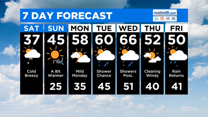
We will have to monitor for even a chance that some southern parts of the region to reach near 70 on Wednesday afternoon.
We should get a quick break with some drier conditions on Thursday before another system moves in by the end of next week that could bring another cool down as well as a few snowflakes to the region once more.