Philadelphia Weather: Potent Cold Front Brings Tornado Watch, Strong Storms To The Region
PHILADELPHIA (CBS) -- After a quiet week across the region we are ending the week on another rainy note, along with the chance for some strong to severe storms at times this afternoon and evening. The National Weather Service has issued a tornado watch for Philadelphia and much of the surrounding region until 9 p.m. Friday.
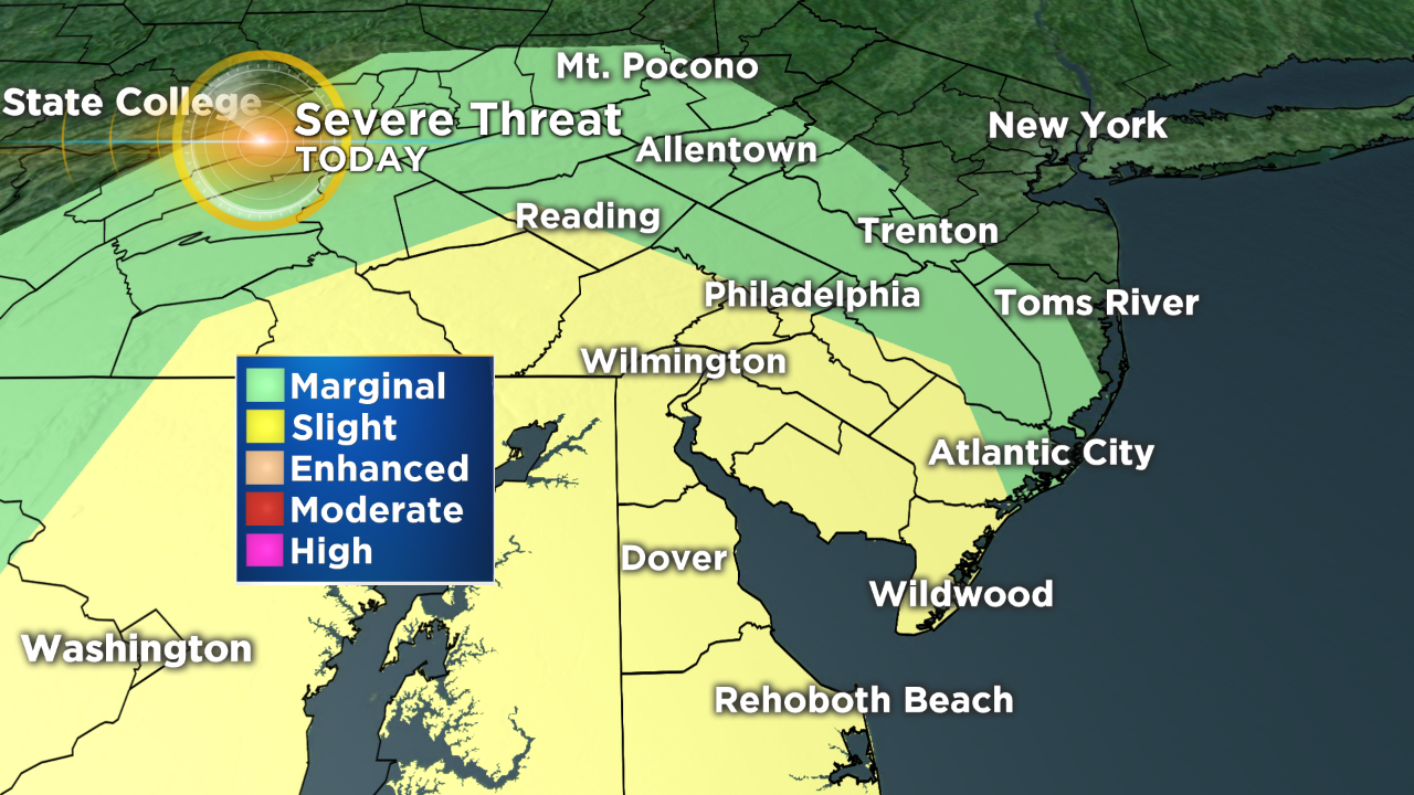
After a quiet week across the region we are ending the week on another rainy note, along with the chance for some strong to severe storms at times this afternoon and evening. The Storm Prediction Center has issued a slight risk for severe storms this afternoon due to the fact that atmospheric conditions will be ripe for rotating supercells to develop. The area that will be under the highest risk for the severe storms today will stay generally south of Philly but storms could still move through northern parts of the area as well.
Conditions this afternoon will become more conducive for severe weather as the day wears on, with warmer and moister air slowly working in, prior to a cold front passing through the region. This afternoon, high dew points and warmer temperatures will lead to an unstable atmosphere and chance for thunderstorm development. There also will be strong "wind shear" or changes in wind speed and direction with height, that will contribute to the potential for rotating thunderstorms.
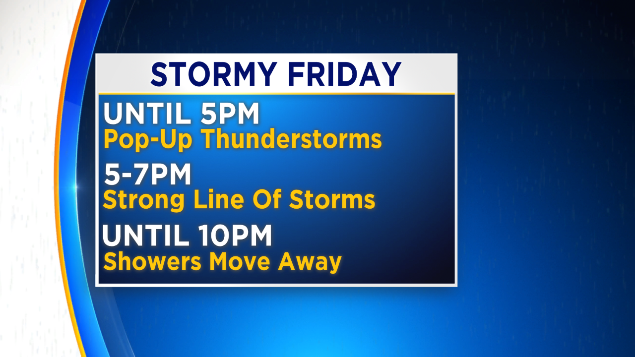
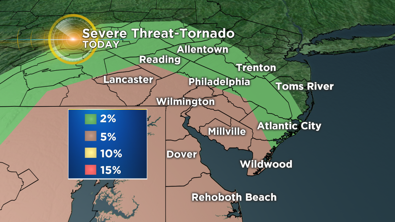
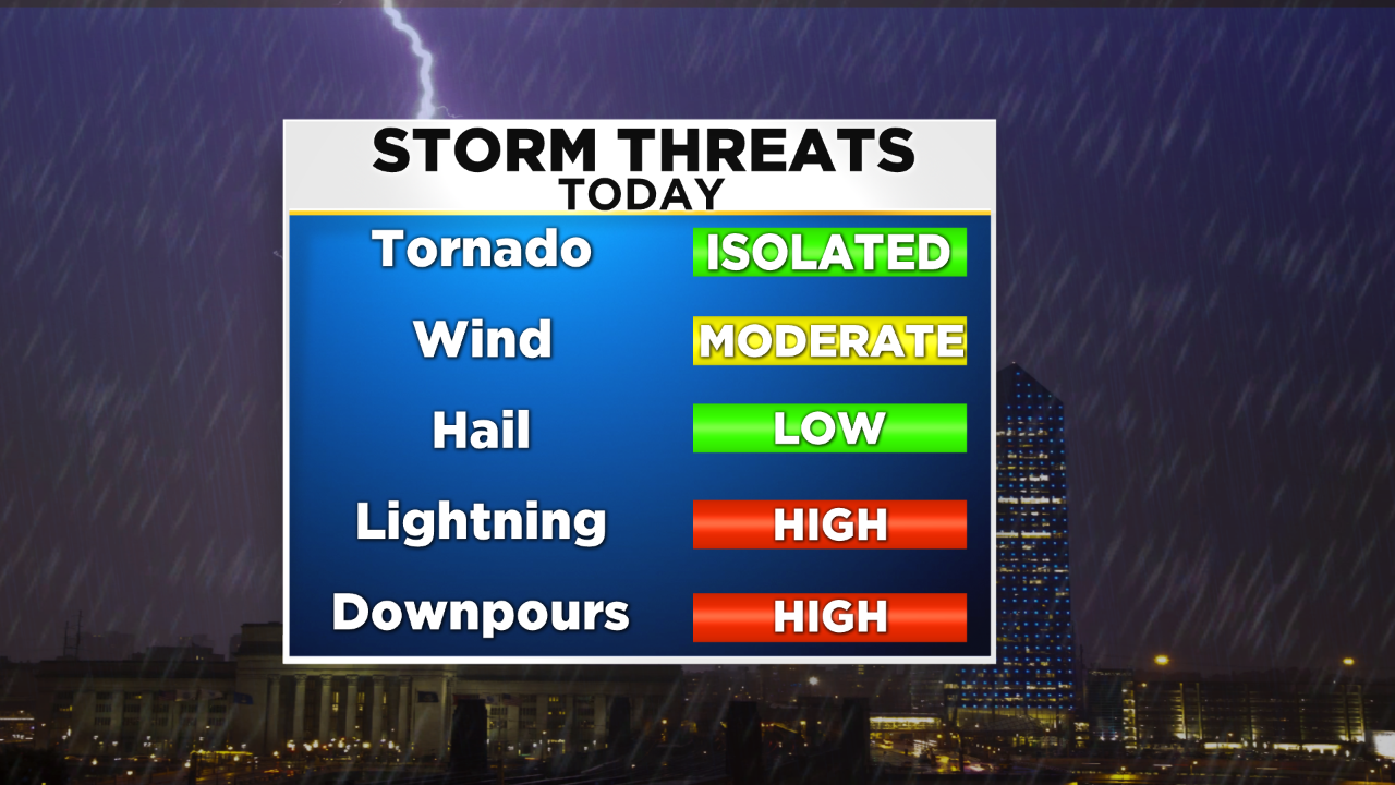
These rotating types of storms are what leads to the development of strong winds, hail or the threat for tornadoes. The thunderstorms that are likely to fire up this afternoon, before the front rolls across are called discrete cell thunderstorms, since they are not part of larger line or system. These types of discrete storms out ahead of the actual front tend to the best chances for tornadoes to develop. While the threat for tornadoes is looking isolated at best, at this time, we will still be following any afternoon thunderstorms closely for upper level rotation. The strong rotating discrete supercells that could develop this afternoon also hold the highest threat for hail. Right now the hail threat is low but again it will be something to be monitored if a strong thunderstorm were to develop. Most of these discrete type thunderstorms would fire up before 5 p.m., and the advancement of the cold front into the region.
As the front rolls through, the severe threat will start to shift from a tornado threat to more of a straight line wind threat. The change in severe weather type is due to the linear nature of the storms that are likely to fire along the actual cold front. While the primary threat with a linear storm complex is strong winds, a chance for spin up tornadoes within the line are still possible. If we were to see severe winds as the cold front moves across, winds could gust as high as 60 or more miles per hour. The timing of this intense line of thunderstorms will be between 5-7 p.m. for the general vicinity of the city. Philly should be in the cross hairs of the possible severe line around 6 p.m.
Once the actual cold front clears the area, we should rapidly quiet down. While a few lingering light showers are still possible after the front pulls through, we really should just start to see some breezy conditions as skies begin to clear out. Overall it looks as though the lingering shower activity could hold on until about 10 p.m. in the far eastern zones in New Jersey, like the shore, while they likely end much sooner the farther west to go from the city.
It is important to remain aware throughout the day as conditions can change rapidly at a moment's notice. Also remember to stay up to date with all of your severe weather information by staying with the Eyewitness Weather Team on TV, online and by downloading the CBS Philly Weather App on your smartphone.