Colder Weather Moves In, Bringing Weekend Snow Chances
Follow CBSPHILLY Facebook | Twitter
PHILADELPHIA (CBS) -- It has been at times a wet start to January and 2019, but with temperatures to start the year that have been well above normal most of the time, all of the precipitation has fallen as rain, with only a few wet snow flakes mixed in here or there from time to time. A changing pattern is going to bring in colder air starting today and with a system brewing for the coming weekend, we could be in store for our first snowfall of the winter season.
In this post we will go over some generalities for the weekend system and what some early predictions are looking like for placement of the highest snow totals. There are more than a few mitigating circumstances that still need to work themselves out before we can really start to nail down amounts for the region.
First off, the set up that is allowing the snow rather than rain to develop this weekend is really thanks to a large area of arctic high pressure that is settling over eastern Canada. This is continuously funneling in cold air and dropping temperatures, not just in the upper atmosphere, but all the way down to the surface as well. This means that melting through the atmosphere is less likely than in previous storm systems that have come through this month.
However, this high that is keeping us cold is also the biggest culprit in keeping the snow out of the area too. With such a strong surface high in place, it means that the low pressure and the moisture associated with it are likely to stay farther to the south, with the bulk of precipitation falling in areas like Baltimore and Washington, D.C.
That doesn't mean we are going to be dry though, it just means we could be actually looking at a more flip flopped snow amounts map than we usually see. Also, as the storm stays to the south, it is harder to draw moisture in from the Atlantic Ocean like we usually see with East Coast winter storm systems. While this particular low will definitely not be moisture-starved, it will also not be moisture-rich either. This is another factor that looks to lead us in the direction of lower snow amounts.
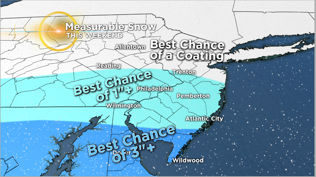
Snow should start to fall in the later portions of Saturday, with the bulk of the snow falling on Saturday night into Sunday morning. We then can expect light snow to continue throughout Sunday, but the main accumulations should have happened before Sunday rolls around. Based on the current southern track and lack of deep moisture for this system we should look for 1 to 2 inches for the I-95 corridor, including Philadelphia, with lower amounts in the coating to 1-inch range as you head to the north and west of the city. This is a departure from usual where those areas tend to see the highest amounts.
As for South Jersey, this system should drop the highest amounts in this area. Across southern New Jersey, we could see 2 to 3 inches, or even slightly more than 3 inches in select spots.
While we are not expecting a lot of snow with this system over the weekend, it will still cause slick roads and dangerous travel, so make sure to not venture out if you have to over the weekend and dust off the snow boots and shovels as we prep for the first snow of 2019.