Extreme Heat Continues Into Another Week
Follow CBSPHILLY Facebook Twitter
PHILADELPHIA (CBS) - We officially turned the page to summer a couple of weeks ago and then over the weekend we turned the calendar to July, also known as the hottest month on average for the Philly area.
Helpful Heat Resources For Pennsylvania, New Jersey And Delaware
The average high for the month is 86 degrees and we are starting things out well above that with temperatures on Sunday that rocketed into the middle and upper 90s, and with another scorching afternoon on tap for Monday and likely through the whole week, July is definitely living up to its climatological history.
As Monday began, we were already in the throes of our first heat wave of the year for Philly and today is just going to be another notch on the old belt for Mother Nature as we look to press toward the triple digits once more this afternoon.
High temperatures on Monday should peak in the upper 90s across the region and when you add in the humidity it will be feeling as hot as 105 degrees-plus in places. This extreme heat and humidity are likely to persist for one more day on Tuesday and while high temperatures could be a couple of degrees cooler, likely topping out in the middle 90s rather than the upper 90s, humidity will still be oppressive which means that the heat index, or temperature it will feel like outside, are still likely to be in the 100-105 range.
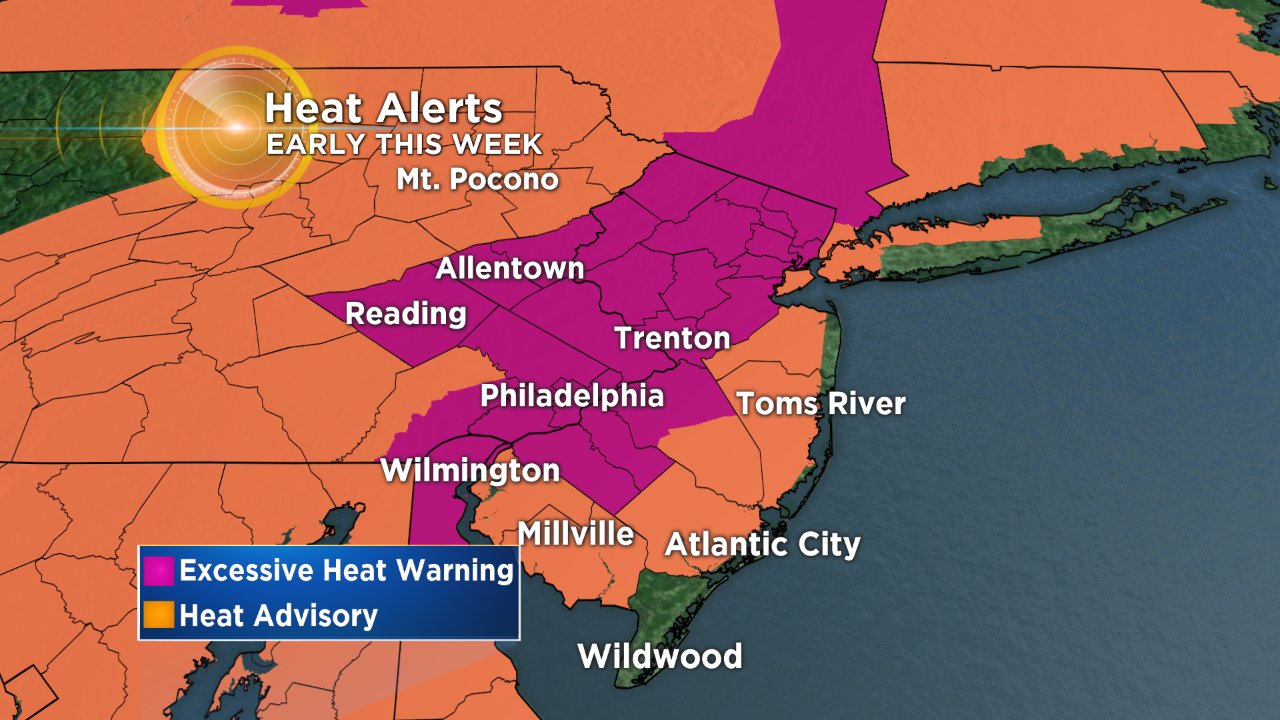
With the dangerous heat and humidity lasting through Tuesday afternoon, there is an Excessive Heat Warning in place for the I-95 corridor until 8 p.m. on Tuesday night. We should start to see some limited relief through the middle of the week but it will not be all that much in the grand scheme of things.
A weak cold front will try to pull through the region later on Tuesday and into Wednesday, but it will washout as it gets close to Philly, so while a couple of hit and miss thunderstorms are not totally ruled out for the 4th of July on Wednesday, it is definitely not going to be a rainy day and it should, in general, stay hot and muggy. Highs for the holiday are likely to reach the lower 90s. The heat index on Wednesday should fall below the 100 mark for the first time since Sunday.
Our limited chances for a thunderstorm continue into Thursday as the heat and humidity combine with another weak boundary that tries to push across the area. Do not expect much in the way of rain or storms on Thursday during the day but a couple of pop-up showers or thunderstorms could be expected in the second half of the afternoon. We should peak in the lower 90s once again on Thursday.
By the end of the week on Friday, a true cold front will work through the region and we could be looking at a legitimate chance for showers or a thunderstorm late on Friday and into the nighttime hours of Friday into Saturday. Temperatures on Friday remain in the lower 90s, but before the front comes through, the humidity could push back up into the more than oppressive range, making it feel close to 100 on the heat index chart.


Thunderstorms become more likely on Friday night and could linger into Saturday morning before clearing out on Saturday afternoon. We look for some legitimate relief from the heat and humidity over the coming weekend, as temperatures fall back into the normal range in the middle 80s both Saturday and Sunday, with humidity that should remain more than comfortable throughout the weekend as well.
Make sure you are staying safe and cool throughout this stretch of extreme heat in the Delaware Valley.