A Nice And Generally Quiet Week For Weather
Follow CBSPHILLY Facebook Twitter
PHILADELPHIA (CBS) -- The rain showed up late on Sunday and then came down fast and furious overnight. It persisted into Monday morning causing plenty of issues on areas roads with flooding and washing out roads for the morning commute.
The good news is that the rain is likely to finish up across most of the region by the lunchtime hour at the latest and we will likely clear out, at least a bit throughout the afternoon hours on Monday. Temperatures to start out the week will be cooler thanks to the rain and the fact that we will be on the backside of a front as well.
Highs on Monday should only top out in the upper 60s to around 70.
High pressure will be in control on Tuesday and it will be a wonderful day with a lot of sunshine throughout the afternoon. Temperatures on Tuesday are going to remain below normal as they top out in the upper 70s but the humidity will be nice and low, leading to an extremely comfortable day.
As we move into the nighttime hours on Tuesday, the next system starts to work into the region and a few showers or an isolated thundershower could develop into Wednesday morning, but those chances are relatively low at this point.
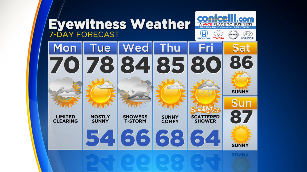
The best chance for any kind of rain or thunderstorm activity this week is going to come on Wednesday as a frontal system that will include the passage of both a warm and cold front will move across the Delaware Valley. This is likely to spark off showers and spotty thunderstorms as well throughout the afternoon.
Temperatures even with the rainy weather on Wednesday should push into the middle 80s.
The rain quickly clears off to the south though by Thursday and high pressure will take over once again. The temperatures on the back side of the front are not going to get much cooler as we still are likely to peak in the middle 80s on Thursday afternoon.
The good news is that the humidity will be very low and should remain comfortable even if it does remain warm.
A final chance for a shower or two is possible to pop up on Friday.
In general, Friday is going to be a mostly sunny afternoon with more temperatures in the lower 80s before a hot weekend takes over with plenty of sunshine and temperatures that peak in the middle to upper 80s on Saturday and Sunday.


TODAY -- Heavy In The Morning, Then Showers, Slowly Clearing Through The Afternoon. High 70
TONIGHT -- Mostly Clear Skies and Cool Lows. Low 54
TOMORROW -- Mostly Sunny, Few Showers Develop Overnight Into Wednesday. High 78
WEDNESDAY -- Mostly Cloudy with Showers and A Spotty Thunderstorm. High 84
THURSDAY -- Sunny and Comfortable. High 85
FRIDAY -- Mostly Sunny, Scattered Shower Possible. High 80
-----------------------------
JERSEY SHORE:
**MULTIPLE FLOODING CONCERNS THROUGH THE MORNING HOURS**
TODAY -- Rain, Heavy At Times In The Morning, Then Showers, Limited Clearing Late In The Day. High 61
TONIGHT -- Mostly Clear Skies. Low 58
TOMORROW -- Mostly Sunny. High 67
OCEAN TEMP: 66°
--------------------------------
POCONOS:
TODAY -- Morning Showers, Then Clearing Skies. High 71
TONIGHT -- Mostly Clear. Low 45
TOMORROW -- Sunny, Showers Could Develop Overnight. High 73