Weather: The Snow Totals We Can Expect For Thursday Morning's Storm
PHILADELPHIA (CBS) -- A high-impact northeast snowstorm is on the way and it's coming on the heels of record-challenging warmth. Get ready for a major swing from "spring" back to winter.
On Tuesday night, a winter storm watch was issued for Philadelphia beginning on Wednesday night, into Thursday.
Temperatures are gradually rising overnight and will stay in the 50's through the overnight hours for most of the region, before rising into the 60's as the sun breaks through on Wednesday.
The record is 63 and it looks like there's a good chance we tie that record. May want to snap a selfie if you're out there in short sleeves enjoying the warmth, because by the next day it'll look completely different.
Cold air will begin to rush into the area late Wednesday night from the north and west. At the same time, an area of low pressure pushing in from the west will move off the coast, and the timing is perfect - the system will rapidly intensify, throwing moisture back to the eastern seaboard just in time for it to meet up with the cold air. This is a recipe for snow, and heavy snow at that.
Here's the current breakdown on timing:
It looks like the snow may start a bit later than originally anticipated, which is good for snow lovers, because the longer it waits, the colder the air will get. Snow will overspread the area between 2:00 a.m., and 6:00 a.m.
I'm not too sold on it starting as rain anywhere north and west of the city, but it will be a wintry mix of rain and sleet for a while in parts of South Jersey and Delaware. The brunt of the storm will occur between 6:00 a.m., and 11:00 a.m., with heavy wet snow falling at rates up to 1" per hour.
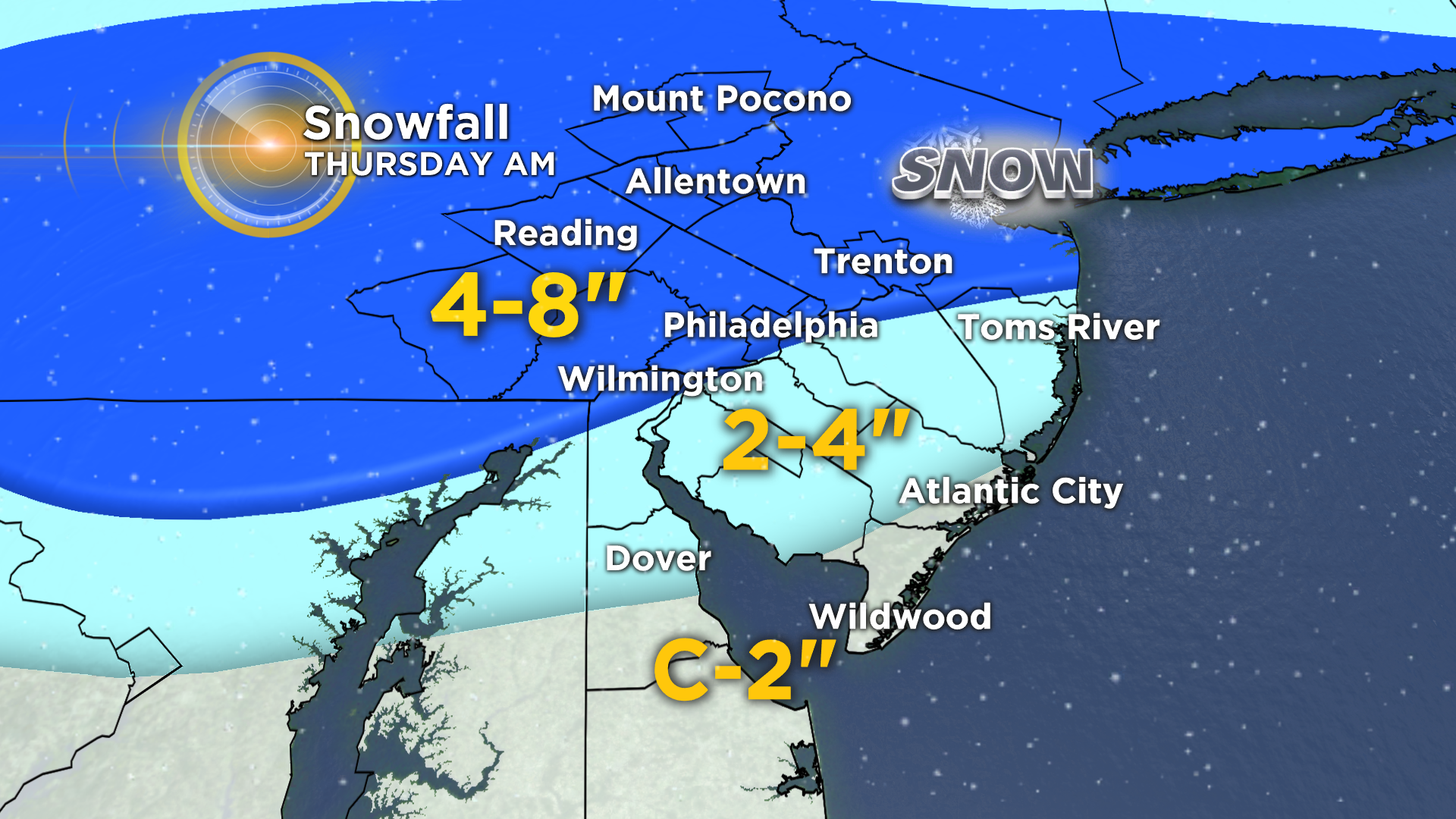
Even at a low 10:1 ratio with temperatures near freezing, it's easy to see how over 4" could quickly accumulate from this system. After 11:00 a.m., the snow will gradually lighten in intensity and taper from west to east before ending by mid-afternoon. Then, the winds pick up and the temperatures continue to drop, meaning wet and slushy roads may refreeze.
This is a wet pasty snow that will cling to tree branches and power lines. While it will look pretty, it does lead to an increased risk for power outages in areas that see the heaviest snow. Winds picking up late on Thursday may also contribute to that risk.
In the wake of all the warmth, roads will initially be warm and respond well to the snow, with melting occurring during the early phase of the storm. But as the snow continues to fall heavily, it will begin to pile up and even main roads may become snow-covered and slushy.
This storm will have a high impact on travel because the heaviest snow will be falling during the Thursday morning commute.
A Winter Storm Watch has already been issued for areas north and west of Philadelphia, where over 6" may fall in spots. Amounts may still be changed or tweaked depending on the exact track of the storm, so check back frequently for updates.
Stay with CBSPhilly.com for the latest on the approaching storm.