Weather Blog: Snow To Usher In Spring Season
By Steven Strouss
PHILADELPHIA (CBS) -- Just last week the temperature in Philadelphia soared to 82 degrees on consecutive days, the highest ever so early in a season. Now we are talking about accumulating snow on the first day of Spring. March is typically a volatile month as Winter and Spring fight it out but shorts and t-shirts to mittens and shovels, within a week, doesn't happen too often. Spring officially arrives at 12:30AM on Sunday and in this case, Winter will win the battle but lose the war.
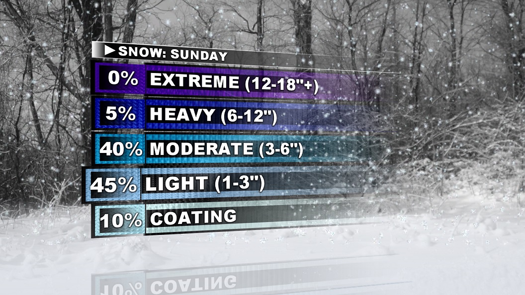
A large coastal storm will bring wet snow to the Mid-Atlantic and New England states on Sunday. Over 6" of snow is possible in parts of Massachusetts, New Hampshire and Maine. Closer to home, I'm putting the over/under at 3" for Philadelphia and surrounding suburbs. Lower amounts are likely along Coastal NJ and Southern DE due to warmer temperatures and mixing.
The setup begins with cold air spilling into the Northeast this weekend. Highs on Saturday will struggle to get out of the 40s despite some sunshine. Meanwhile, an organizing area of low pressure along the Gulf states will gather moisture and head up the coast and snow will overspread the area from the southwest late Saturday night. This is a tough forecast because the exact timing and intensity remain uncertain and despite coastal intensification, it remains to be seen how much warm air gets pulled in and far out to sea the low tracks. Other limiting factors include a high March sun angle and recent warm temperatures. With several pieces coming together to form this system, a lot can change and that's why this storm needs to be watched closely as we head through the weekend.
This is the type of snow that is most likely to accumulate on grassy surfaces and stick to trees and power lines. Other impacts will include slow travel, gusty winds and minor coastal flooding. Be prepared for an all day event but afternoon high temperatures will be above freezing and that will assist with melting.
As the storm departs, gusts could exceed 35 mph into Monday and it will remain chilly with highs only in the low 40s.
Looking forward it is promising that this will be the last snow of this season as temperatures rebound into the 60s next week and we move into a milder pattern. Stay with the Eyewitness Weather team for updates through the weekend as we watch and update the progression of our Spring Snowstorm.