Much Drier Stretch In Store Heading Toward The Holiday Weekend
Follow CBSPHILLY Facebook Twitter
PHILADELPHIA (CBS) -- Usually we like to talk about how April showers bring May flowers, but if you have been outside in the Philly area at all over the last 10 days or so, you know that it has been more like May showers give us dreary weather.
Over the last 11 days, 10 of them saw at least a trace amount of rainfall. Almost an inch-and-a-half fell a few Saturdays ago on May 12.
The frontal system that was the main player for all the damp conditions finally moved far enough away from the region in the second half of Sunday so that sunshine actually came out. This is why we had a summerlike afternoon with some higher humidity at times.
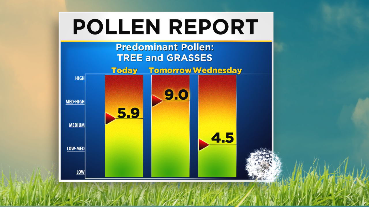
As we prep for the unofficial start to the summer season this coming weekend with Memorial Day right around the corner, it is good to see a much quieter week in store for the area.
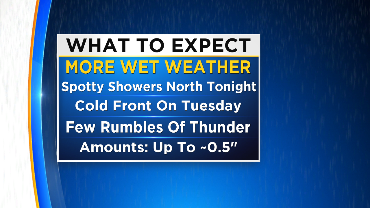
Over the next five to seven days, we are going to watch for drier weather overall, but a few spotty shower or thunderstorm chances will be in the mix from time to time.
The first of the rain chances will come tonight as a few spotty light rain showers could develop across the Poconos as a new boundary works into the region. For the most part, the area will stay dry tonight.
A cold front will move into and through the Delaware Valley on Tuesday making it possible for showers and even an isolated rumble of thunder in the afternoon. A few of those showers could linger into Wednesday, but it looks as though Wednesday will generally be dry for the region.
We should watch high-pressure build in as well, likely clearing us out pretty nicely for the second half of the work week. Rain amounts for the next couple of days will likely only top out around a half inch, but there is the potential for slightly higher amounts if you are caught in a thunderstorm on Tuesday.
Temperatures this week will definitely be more summer than springlike as we see highs rise from the middle to upper 70s on Monday and Tuesday into the middle 80s in the second half of the week and into the holiday weekend as well.
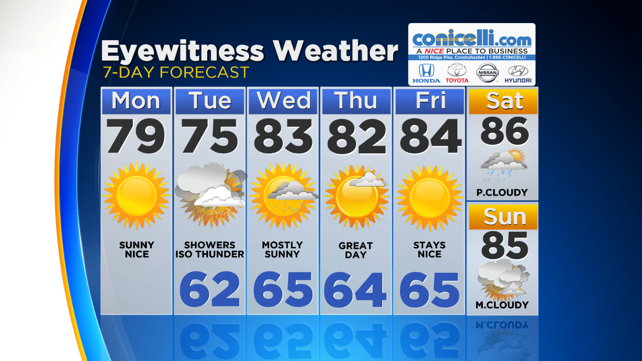
A quick peek into the Memorial Day weekend shows that we should be keeping an eye to the sky as showers could be possible Saturday to Monday. High temperatures will likely stay in the 80s.
None of the days over the weekend at this point seem like they will be a washout but just make sure you are staying up to date with the forecast by staying tuned to CBS Philly and following us on Social Media and on our Weather App.

TODAY -- Sunny and Warm. High 79
TONIGHT -- Partly Cloudy Skies. Low 62
TOMORROW -- Mostly Cloudy to Overcast, Showers with Isolated Rumbles Of Thunder. High 75
WEDNESDAY -- Mostly Sunny, Spotty Rain Showers. High 83
THURSDAY -- Mostly Sunny. High 82
FRIDAY -- Sunny and Warm. High 84
---------------------------------
JERSEY SHORE:
TODAY -- Mostly Sunny. High 70
TONIGHT -- Partly Cloudy. Low 56
TOMORROW -- Mostly Cloudy, Showers, Isolated Thunder. High 71
OCEAN TEMP: 60°
-----------------------------------
POCONOS:
TODAY -- Mostly Sunny. High 72
TONIGHT -- Mostly Cloudy, Showers Possible. High 54
TOMORROW -- Overcast With Showers or Thunderstorm Possible. High 63