Strong Coastal System Set To Develop Thursday Afternoon
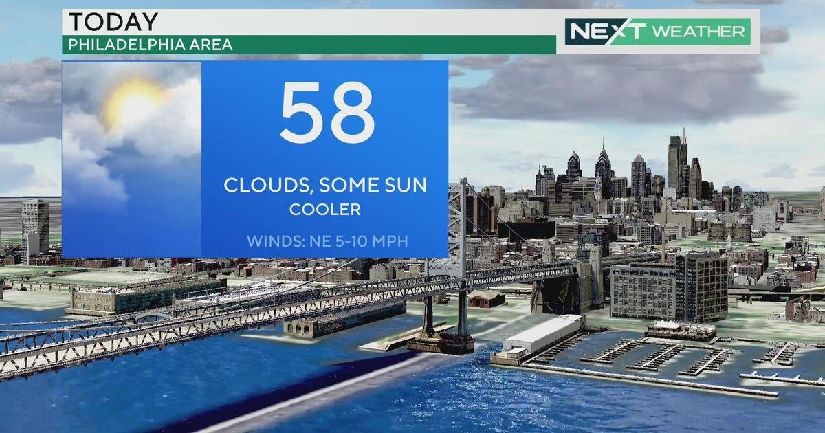
PHILADELPHIA (CBS) - So far this week, the forecast has really been to almost everyone's liking thanks to sunshine and the temperatures that have remained above normal. Unfortunately, as the saying goes, all good things must come to an end, and we are going to be come to quite an end not just in the sense of the nicer weather moving out, but we also end the month of February and start March with a bang.
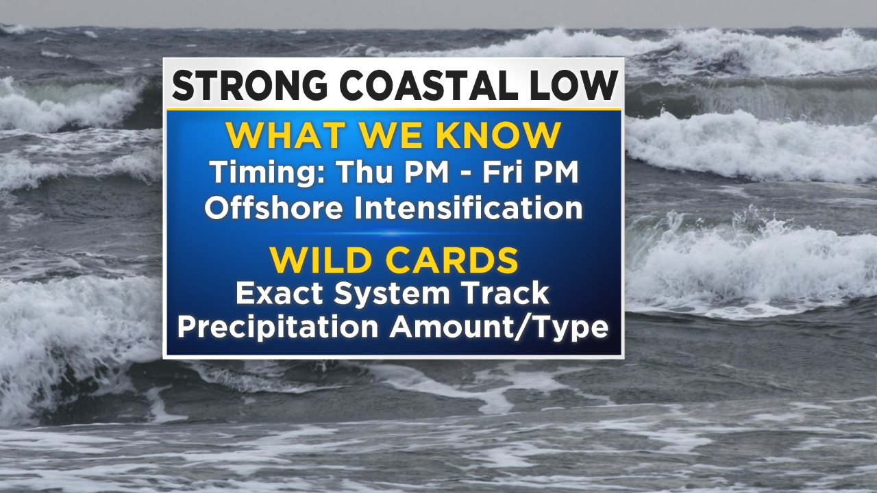
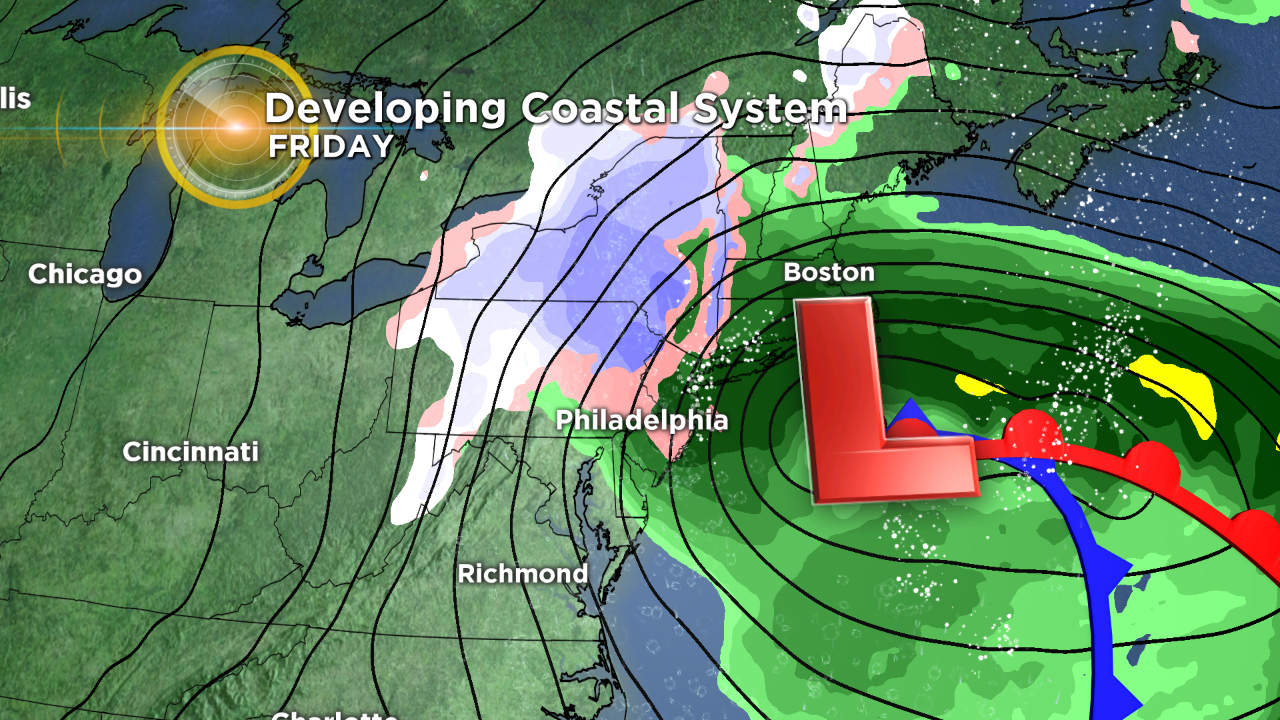
Most of the talk throughout the first couple days this week has been about the chances of a coastal low pressure system that could develop and cause some issues across the region, and it looks as though that picture is coming into more focus as we get closer to the end of the work week.
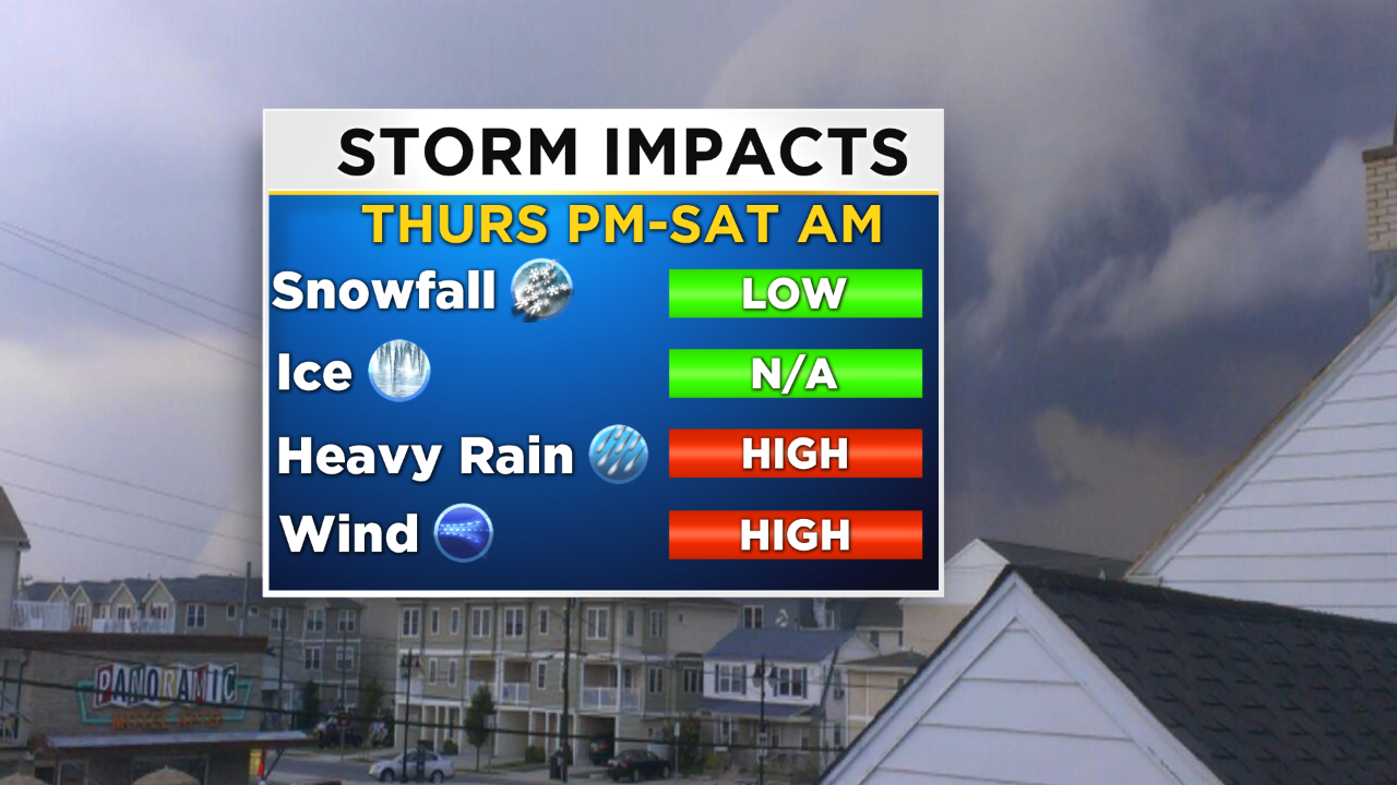
The nasty weather that moves in starting on Thursday afternoon and lasting until the morning hours on Saturday will be composed of two parts. The first being a low pressure center that moves in from the Great Lakes region, while another develops in the Southeast and slowly moves into the area. These two pieces of energy are eventually expected to phase or merge just off the coast of New Jersey on Friday and then likely spiral off the coastline for another 24 to 36 hours before it finally slowly inches its way out to sea, as an area of blocking high pressure breaks down.
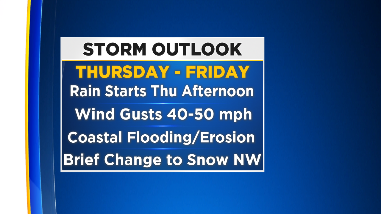
This system will start moving into the area on Thursday afternoon, in the form of rain showers, that are going to spread over the region from south to north throughout the day. While the rain is expected to be heavy throughout the entire day, pockets of heavy downpours are still likely. Winds will really begin to pick up in the later parts of Thursday and then peak as move into Thursday night, Friday and Friday night, before eventually calming going to Saturday. We will dive into how strong winds get and effects of the winds below.
Riding in on the back of the strong winds, especially on Friday and then Friday night, are colder temperatures. We could see temperatures fall from the 50s to 30s in some areas. What this all means is that there is a chance for a change over from rain to wintry mix of rain and snow or even a change to all snow for portions of the region, especially north of Philly in the higher elevations, but a few snowflakes or a snow shower could even work its way into the I-95 corridor, depending on how fast the cold air rushes in on the back side of the low, which at this point will be spiraling off the coast of New England.
By the time we move into Saturday morning, almost all, if not all, precipitation should be clearing the area and, in general, Saturday should just be cooler and breezy with a mix of sun and clouds. That pattern will last throughout Sunday as well.
As promised, we are going to discuss the potential threats with this system which at this time are the strong winds, potential for locally heavy rain, and effects of coastal flooding along the Jersey Shore.
Wind and the coastal effects are the main concern so we will start with them. We can expect winds to start to pick up on Thursday night, and by the time we reach Friday morning, gusts could be as high as 35 to 50 mph along the shore points.
We will also be dealing with a short time of onshore flow on Thursday night while winds are starting to increase, which could push some extra water onshore, leading to the potential for coastal flooding as early as Thursday night. The threat of coastal flooding is likely to then increase on Friday and Friday night as we deal with successive high tides coupled with the extra rainfall. The highest water is likely seen associated with the Friday morning high tide.
Beach erosion is possible as well thanks to high swells coupled with whipping winds. Winds throughout the duration of this system will be brutal. Gusts throughout the event could reach as high as 50-plus mph along the coast, with gusts even inland and near Philly pushing to near 40-plus mph at times. This means we will need to monitor for downed tree limbs and power lines, which could lead to power outages, especially again along the coast. Finally, rain amounts, in general, will hover around an inch or so much in localized spots but there is the potential for up to 2 inches-plus, which could cause localized flooding problems.
Last, I mentioned above a chance for a brief change over to a rain-snow mix or even purely snow for some spots, mainly on Friday and then Friday night. This will all depend on how fast the cold air rushes in behind the low. The colder temperatures will reach areas in the Poconos and Lehigh Valley first and we could be looking for a change over to accumulating snowfall in these areas before the system clears the region.
Right now there is a lot of uncertainty on when/if the change over happens and how much snow could fall, so for the time being I will refrain from putting amounts in this forecast, but will continue to monitor the snow potential closely.
This system, while coming more into focus recently, still has plenty of moving parts which continue to have to be monitored closely. Make sure to are staying with the Eyewitness Weather Team for all your forecast updates we get closer to Thursday afternoon.