Blizzard Warning Issued For Parts Of New Jersey
PHILADELPHIA (CBS) -- Some New Jerseyans are being advised to brace for a blizzard that could drop a lot of snow in coastal areas and cause dangerous subzero wind chills.
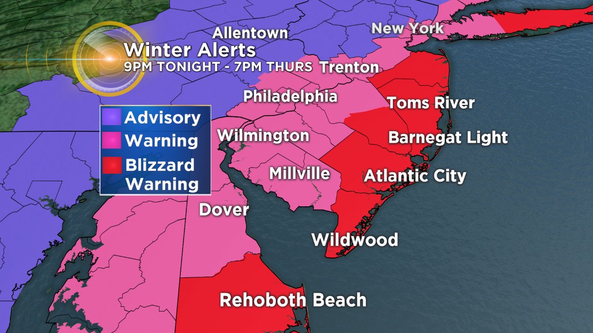
There is a blizzard warning in effect Wednesday evening through Thursday night for coastal New Jersey counties as the Jersey Shore could see 6 to 10 inches of snow.
There is winter storm warning in effect Wednesday evening through Thursday night along the I-95 corridor into portions of South Jersey, northern and central Delaware where areas could see 3 to 6 inches of snow.
And there is winter-weather advisory in effect during the same time frame north and west of I-95 and those areas could see 1 to 3 inches.
Travel Alerts Issued As Powerful Nor'easter Hits Northeast
The first snowfall of 2018 is in the forecast as a strong Nor'easter gets ready to pass by us, likely dropping substantial snow along coastal New Jersey with strong winds and bone-chilling temperatures to follow for the entire region.
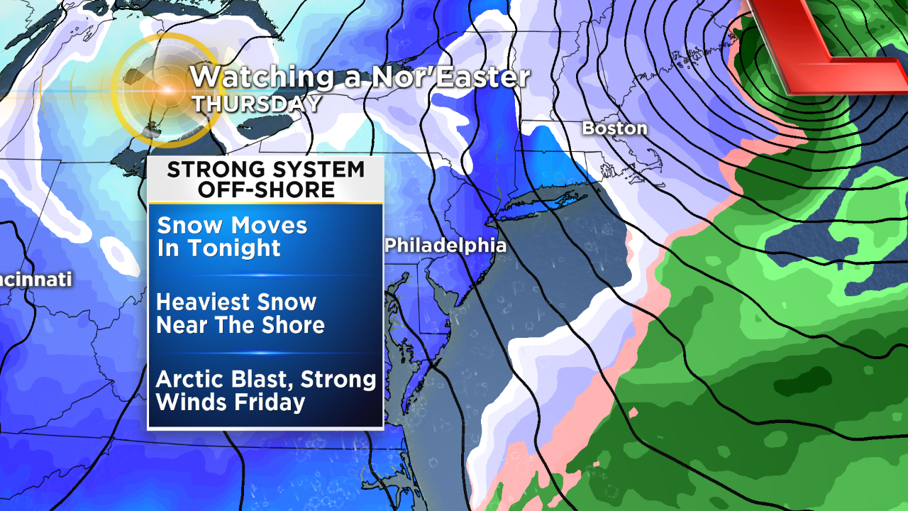
Our set-up is coming together decently in the southern U.S. for a potent system to develop and move into the region starting tonight, peaking in intensity for our area on Thursday afternoon, before racing off into New England by Thursday evening.
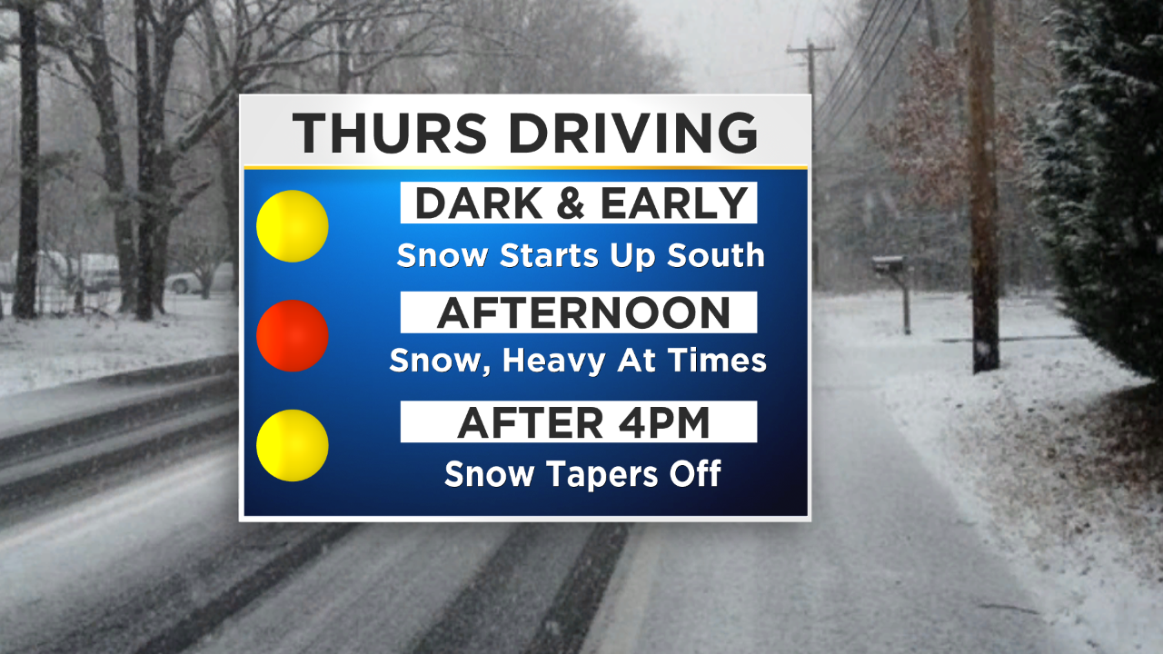
Timing for this system is rounding into form pretty nicely and has not changed much from what we were looking at on Tuesday. Snow will begin in the later evening and early overnight hours in areas south of Philly, likely in southern Delaware and far south New Jersey, and spread to the north throughout the night and in the daylight hours on Thursday morning.
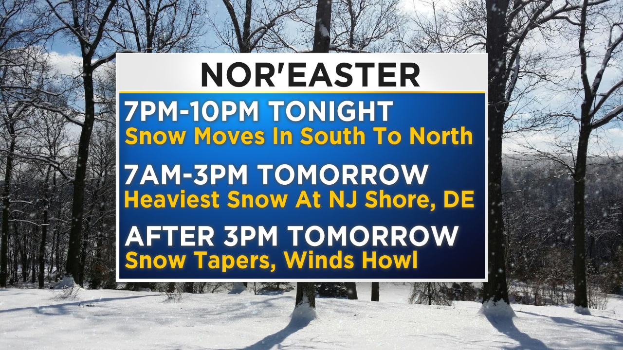
At this time we can expect snow to start to fly in the Philly metro around the 2 to 3 a.m. time frame on Thursday morning, with spots north and west of the city possibly seeing a few flakes just before sunrise Thursday. As the storm progresses up the coast, the time frame of the heaviest snowfall is going to be in the morning and into the early afternoon on Thursday, likely ending around 4 p.m. or slightly before for basically the whole region, with just a few flurries that will last into the later afternoon and evening hours tomorrow.
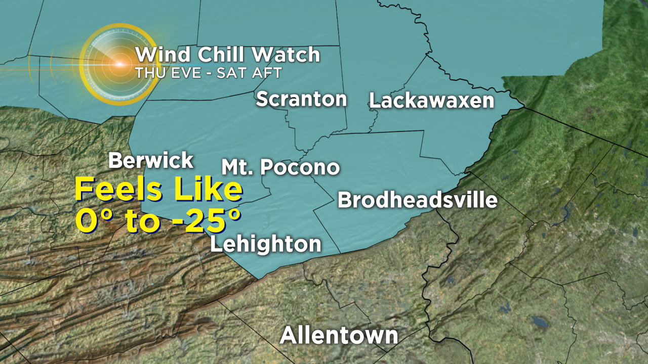
The moisture-rich part of the system should be totally out of the region by Thursday night and the extreme cold and strong winds will then start to take over as we move into the Thursday night and Friday time frames, with the extreme cold and dangerous wind chills pushing into the start of the weekend as well.
Philadelphia Declaring Snow Emergency Ahead Of Winter Storm
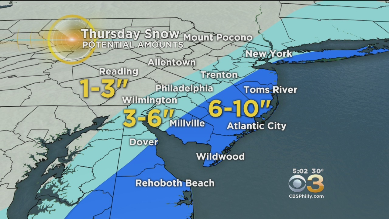
Snow amounts are always a main concern with winter storms like this and amounts with this system have the potential to be on the higher side in areas, especially along the coastline of New Jersey, but there is going to be a sharp drop-off as we head inland into New Jersey and close to the I-95 corridor. Snow amounts in coastal New Jersey at this time are likely to be in the 6- to 10-inch range from Toms River down into Southern Delaware. Inland New Jersey and into Philly is in the 3- to 6-inch range, but again, expect a sharp drop off in amounts in this area due to the nature of the position of the storm off the coast.
Some areas could see closer to 3 inches while spots only a couple miles away could be much closer to 1 inch or even slightly less.
Finally, if you happen to live in the north or west suburbs and into the Lehigh Valley and Poconos, you are likely to miss out on this storm completely, save for a chance of a coating in a couple isolated areas. Even though amounts may vary a bit and there is the potential for a bust factor, strong winds and the snow will lead to tough driving conditions, with slick roads and low visibility so a Winter Storm Warning will be in effect starting this evening lasting through Thursday afternoon along the Jersey coast and a Winter Weather Advisory for inland New Jersey up to the boarder with Pennsylvania.
After the system moves away, the cold and wind will pick up and temperatures on Friday and Saturday are likely to only top out in the middle teens for Philly and possibly only the single digits in areas north of the city. When you add in the wind, wind chill values will be feeling like teens to even potentially 20 below zero at times. This extreme cold will persist into the start of the weekend before we look to get a quick burst of relief heading into the start of next week.
Make sure to stick with the CBS3 Eyewitness Weather Team on-air and online as the forecast this week develops.