What Will Winter 2016 Bring To The Philadelphia Region?
PHILADELPHIA (CBS) -- On November 9, meteorologist Katie Fehlinger and I presented the CBS3 Eyewitness Winter Weather Forecast for the coming year! In case you missed it, here are some of our main talking points, factors we took into consideration, and a basic overview of what this winter could bring.
I must add my annual disclaimer that it's impossible to predict, with any true accuracy, exact snowfall amounts for a three-month period, as this is driven by when and where storms develop, and snowfall totals can vary not only county to county, but based on things like the time of day the snow falls. It's a highly variable thing, but instead of taking the numbers at face value, we prefer to look at them as where they stand relative to normal.
Coast Guard Rescues Two Boaters Near Lewes
All that being said, we'll lead with the good stuff. We expect this to be a relatively "normal" winter in Philadelphia, if there is any such thing. In the past ten years, we've had our top two snowiest winters, our third warmest winter, our warmest December on record, and even a winter that produced minimal snow. So "normal" is a tough thing to come by lately. But with the lack of one major driving force (like last year's El Nino), chances look good to have a traditional cold, somewhat snowy winter this year.
 The normal snowfall amount in a given year in Philadelphia is around 22.4". We expect snowfall totals to slightly exceed the normal, checking in at 24-30" for the season. This total will likely be comprised of a number of small, frequent storms, but of course we can't rule out the possibility of a major storm - this would skew the totals accordingly!
As far as temperatures are concerned, we expect a much faster arrival of cold than we saw last year, and it will feel much colder than last year as well. But compared with the average, we believe this winter will end up just slightly below average on the cold scale, with the chance for several periodic but possibly not lengthy blasts of cold arctic air.
Temperatures:
- Dec - slightly below average
- Jan - well below average
- Feb - near or slightly above average
Total departure from normal around -1-2 degrees.
Driving Factors:
ENSO - This winter will likely end up a weak La Nina year. The latest observation of ONI was at a -0.5 and the current projections are 70% chance La Nina will develop, 55% chance it will persist through the winter. La Nina in a weak state means this will not be a textbook Nina winter, but could have some predominant La Nina tendencies like frequent shots of cold from the Great Lakes and a greater potential for clippers and cutters (smaller, more frequent storms).
SIBERIAN SNOW AND ARCTIC SEA ICE - this October marks a record for Siberian snow cover. An increased Siberian snowpack and sustained cold over that region tends to cause a poleward heat flux, which in turn weakens the polar vortex. The weaker the PV, the better chance it splits or breaks off, allowing cold arctic air to descend into Europe and North America. Bolstering this theory is the fact that arctic sea ice is at a near-record low this year - this tends to be another indication of a weak polar vortex.
BLOCKING and SEA SURFACE TEMPERATURE - The pattern this winter appears to be more favorable for at least several periods of blocking, if not a sustained Greenland block. This can be seen by looking at the cold pool of SST's in the north Atlantic contrasted with the warm water off the east coast. The warm water off the coast could provide strengthening to storms along the coast but could also present P-Type issues.
The Best Time To Look For The Super Moon Of The Century
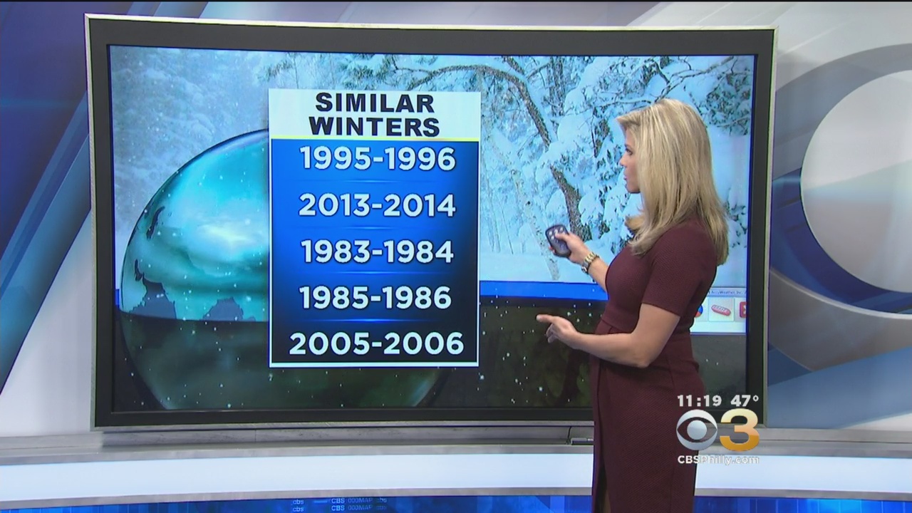
Based on these factors, it appears the closest analog years to this winter are: 1995-1996, 2013-2014, 1983-1984, 1985-1986 and 2005-2006. The first two are scary, as both of these were over 60" snow winters and appear in the top 3. 1996 still holds the record for our single largest snowfall - 30.2" in the blizzard of 1996. But since the chances of a major blizzard in this type of setup are rare, and since 2013-2014 was a remarkable, once-a-century type year in the number of storms, the actual snowfall amounts shouldn't be given as much weight. The average snowfall for these 5 years is 38.2". If you subtract the blizzard, it takes you down to 32". And if you then take out '13-14 altogether just for being such an outlier, you're down to 23", or a pretty normal winter.
Main takeaways:
-Based on the Siberian snowpack and the split Polar Vortex, it appears the shift to cold this winter will happen soon, likely by Dec. 1.
-Winter likely to be more front-loaded than recent years, with December and January being the coldest months relative to normal.
-January looks like the coldest month overall, with the cold possibly continuing into early February.
-There is the possibility of warming in mid-to-late February or March, leading to at least a chance for an early spring this year.
-Storms will be more frequent, but not as large. Chances of a major blizzard or nor'easter are lower than in a Nino winter, but not non-existent. If one of these storms occurs, like the Blizzard of '96, snow totals may be way off.
-Possibility of ice storms if La Nina holds and the southeast warms -Overall, we are predicting a rather "normal" winter for Philadelphia, with temperatures averaging near or slightly below normal, and snowfall slightly above normal.