Winter Woes Continue
By Geoff Bansen
PHILADELPHIA (CBS) -- Hey, it IS winter after all!
After a weekend of dangerous cold, the Delaware Valley now prepares for snow.
We didn't quite get the record low for Monday in Philadelphia (2 degrees, set back in 1888). But boy were we close! Philadelphia saw a low of 3 degrees this morning. Reading and Atlantic City both set new records, however, while Wilmington tied its previous mark. With the wind, it was almost unbearable heading to work this morning. Despite the diminishing wind, chills ranged from -10 to -20 degrees. By this afternoon, wind chills will rise back above zero with lighter winds.
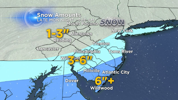
The weather pattern remains active with another storm system approaching the Delaware Valley late Monday night into Tuesday morning. Low pressure currently over the central U.S. will track into the mid-Atlantic Monday night. Cold temperatures are firmly in place, so expect all snow for the entire region. Since the center of the storm will pass by to our south, the highest accumulations will be in Southern NJ, the NJ Shore & central Delaware. A winter storm warning is in effect Monday night through Tuesday morning for all counties south and east of Philadelphia, while Philly and areas north and west are in a winter weather advisory. Snow will begin to arrive late Monday night, with the heaviest snow from 3 a.m. – 7 a.m. Tuesday morning. Expect snow covered roads and low visibility for the Tuesday morning commute. Since temperatures will be cold this will be a light powdery snow, easy to shovel, great for skiing, but terrible for snowballs. The snow will taper off and end by mid to late morning on Tuesday.
Here is our exclusive CBS3 snowfall map: